IMAGES TAKEN NEAR TO
Kerves Lane, HORSHAM, RH13 6RL
Introduction
This page details the photographs taken nearby to Kerves Lane, RH13 6RL by members of the Geograph project.
The Geograph project started in 2005 with the aim of publishing, organising and preserving representative images for every square kilometre of Great Britain, Ireland and the Isle of Man.

There are currently over 7.5m images from over14,400 individuals and you can help contribute to the project by visiting https://www.geograph.org.uk
Image Map
Images are licensed for reuse under creativecommons.org/licenses/by-sa/2.0
Notes
- Clicking on the map will re-center to the selected point.
- The higher the marker number, the further away the image location is from the centre of the postcode.
Image Listing (43 Images Found)
Images are licensed for reuse under creativecommons.org/licenses/by-sa/2.0
Image
Details
Distance
6
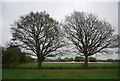
Two trees by the footpath, Amiesmill Farm
Image: © N Chadwick
Taken: 2 May 2010
0.08 miles
7
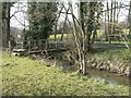
Footbridge over the river Arun
The concrete beam footbridge carries the footpath from Amies Mill south west to Bulls farm.
Image: © Peter Cox
Taken: 1 Apr 2007
0.08 miles
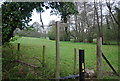
9
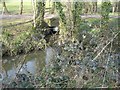
Hornbrook junction with river Arun
The Hornbrook stream runs down from St Leonards forest tojoin the river Arun at Amiesmill.
Image: © Peter Cox
Taken: 31 Mar 2007
0.09 miles
10
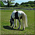
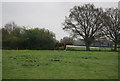
Horse near Amiesmill Farm
I don't know much about horses, but I would say that this one has a very fine and well-groomed tail.
Image: © Ian Hawfinch
Taken: 15 May 2020
0.10 miles