IMAGES TAKEN NEAR TO
Brighton Road, HORSHAM, RH13 6PP
Introduction
This page details the photographs taken nearby to Brighton Road, RH13 6PP by members of the Geograph project.
The Geograph project started in 2005 with the aim of publishing, organising and preserving representative images for every square kilometre of Great Britain, Ireland and the Isle of Man.

There are currently over 7.5m images from over14,400 individuals and you can help contribute to the project by visiting https://www.geograph.org.uk
Image Map
Images are licensed for reuse under creativecommons.org/licenses/by-sa/2.0
Notes
- Clicking on the map will re-center to the selected point.
- The higher the marker number, the further away the image location is from the centre of the postcode.
Image Listing (126 Images Found)
Images are licensed for reuse under creativecommons.org/licenses/by-sa/2.0
Image
Details
Distance
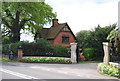
1
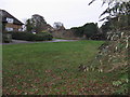
Derelict buildings east of Long Hill Crabtree
Image: © Dave Spicer
Taken: 28 Nov 2009
0.01 miles
8
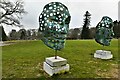
Leonardslee Gardens, Anton Smit 'Walk of Life' Exhibition
Image: © Michael Garlick
Taken: 6 Feb 2022
0.07 miles
10
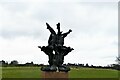
Leonardslee Gardens, Anton Smit 'Walk of Life' Exhibition
Image: © Michael Garlick
Taken: 6 Feb 2022
0.08 miles