IMAGES TAKEN NEAR TO
Ashfold Crossways, HORSHAM, RH13 6PB
Introduction
This page details the photographs taken nearby to Ashfold Crossways, RH13 6PB by members of the Geograph project.
The Geograph project started in 2005 with the aim of publishing, organising and preserving representative images for every square kilometre of Great Britain, Ireland and the Isle of Man.

There are currently over 7.5m images from over14,400 individuals and you can help contribute to the project by visiting https://www.geograph.org.uk
Image Map (8 Images)


Getting Data...Please wait
Leaflet Map data © OpenStreetMap
Images are licensed for reuse under creativecommons.org/licenses/by-sa/2.0
Notes
- Clicking on the map will re-center to the selected point.
- The higher the marker number, the further away the image location is from the centre of the postcode.
Image Listing (8 Images Found)
Images are licensed for reuse under creativecommons.org/licenses/by-sa/2.0
Image
Details
Distance
1
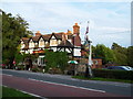
The Wheatsheaf, Plummers Plain
A charming public house on Handcross Road in Plummers Plain.
Image: © David Molyneux
Taken: 5 Sep 2005
0.03 miles
2
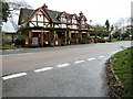
The Wheatsheaf on the B2110 at Ashfold Crossways
Image: © Dave Spicer
Taken: 13 Mar 2011
0.03 miles
4
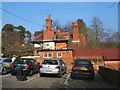
The Wheatsheasf Pub
Located in Plummers Plain, 4 miles from Horsham, details http://www.beerintheevening.com/pubs/s/16/1675/Wheatsheaf/Plummers_Plain
Image: © Paul Gillett
Taken: 15 Mar 2012
0.04 miles
5
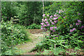
Turn right at the rhododendron
The public footpath through the woods takes an indirect route and mingles with various access tracks, but is quite well signed.
Image: © Robin Webster
Taken: 9 Jun 2010
0.17 miles
6
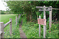
Warren Virgate - private property
The sign at a footpath cross ways seems in some contradiction with the public footpath finger post, and also with itself. Its small print goes on to say "Highways Act 1980 - section 31(3). No public right of way. Do not trespass. Please keep to the public footpath".
Image: © Robin Webster
Taken: 9 Jun 2010
0.18 miles
7
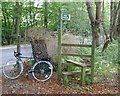
Stile on Public Footpath leaving B2110 at The Warren, Near Handcross, West Sussex
This path meets the B2110 on its N side. A well built two step stile for crossing the 4 foot fence. The course of the path through the wood is not immediately clear from the stile. Heavy undergrowth was prevalent in all directions.
Image: © Pete Chapman
Taken: 8 Oct 2005
0.20 miles
8
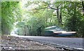
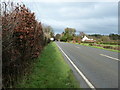
B2110 Road between Handcross and Lower Beeding, West Sussex, Adjacent to The Warren
A well used rural B road. View taken from the S side of the road, looking SW. The road follows a gentle downward incline here towards Ashfold Crossways Image Light levels were quite low under the canopy of the trees and a long exposure was required to take the photo.
Image: © Pete Chapman
Taken: 8 Oct 2005
0.20 miles