IMAGES TAKEN NEAR TO
Winterpit Lane, HORSHAM, RH13 6LX
Introduction
This page details the photographs taken nearby to Winterpit Lane, RH13 6LX by members of the Geograph project.
The Geograph project started in 2005 with the aim of publishing, organising and preserving representative images for every square kilometre of Great Britain, Ireland and the Isle of Man.

There are currently over 7.5m images from over14,400 individuals and you can help contribute to the project by visiting https://www.geograph.org.uk
Image Map (Loading...)


Getting Data...Please wait
Leaflet Map data © OpenStreetMap
Images are licensed for reuse under creativecommons.org/licenses/by-sa/2.0
Notes
- Clicking on the map will re-center to the selected point.
- The higher the marker number, the further away the image location is from the centre of the postcode.
Image Listing (17 Images Found)
Images are licensed for reuse under creativecommons.org/licenses/by-sa/2.0
Image
Details
Distance
1
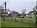
Houses, Winterpit Lane, Mannings Heath
From left to right: Brambletye, Little Mannings and Oak Tree House. There is fourth, Fairoaks, out of shot to the right.
Image: © Simon Carey
Taken: 26 Dec 2023
0.01 miles
2
Quarries Cottage, Winterpit Lane, Mannings Heath
Marked on Nuthurst's 1845 tithe map.
Image: © Simon Carey
Taken: 26 Dec 2023
0.04 miles
3
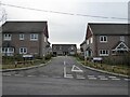
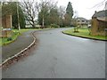
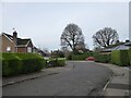
Holly Farm Close, Mannings Heath
A cul de sac off Winterpit Lane completed in September 2022.
Image: © Simon Carey
Taken: 26 Dec 2023
0.05 miles
4
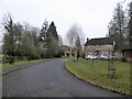
The Quarries, Mannings Heath
A cul de sac off Winterpit Lane that was built in the early 1990s. There were quarries in the former field and later a house called The Quarries prior to this development.
Image: © Simon Carey
Taken: 26 Dec 2023
0.08 miles
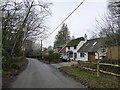
6
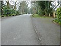
Winterpit Lane entering Mannings Heath from the east
Image: © Dave Spicer
Taken: 13 Mar 2011
0.12 miles
7
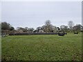
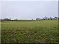
Furze Field
The name of the field according to Nuthurst's 1845 tithe map located to the imnmediate south of Forest Farm.
Image: © Simon Carey
Taken: 26 Dec 2023
0.12 miles
8
Heath Close, Mannings Heath
A cul de sac off Limekiln Road.
Image: © Simon Carey
Taken: 26 Dec 2023
0.16 miles
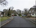
9
Winterpit Close, Mannings Heath
A cul de sac of Winterpit Lane that was built around the end of the 1970s.
Image: © Simon Carey
Taken: 26 Dec 2023
0.19 miles
10
Six Acres
The name of the field according to Nuthurst's 1845 tithe map located on the western side of the public footpath that links Monks Gate to Winterpit Lane.
Image: © Simon Carey
Taken: 26 Dec 2023
0.20 miles