IMAGES TAKEN NEAR TO
Nuthurst Road, HORSHAM, RH13 6LG
Introduction
This page details the photographs taken nearby to Nuthurst Road, RH13 6LG by members of the Geograph project.
The Geograph project started in 2005 with the aim of publishing, organising and preserving representative images for every square kilometre of Great Britain, Ireland and the Isle of Man.

There are currently over 7.5m images from over14,400 individuals and you can help contribute to the project by visiting https://www.geograph.org.uk
Image Map
Images are licensed for reuse under creativecommons.org/licenses/by-sa/2.0
Notes
- Clicking on the map will re-center to the selected point.
- The higher the marker number, the further away the image location is from the centre of the postcode.
Image Listing (68 Images Found)
Images are licensed for reuse under creativecommons.org/licenses/by-sa/2.0
Image
Details
Distance
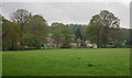
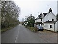
2
Nuthurst Road with footpath junction before houses
Image: © Shazz
Taken: 7 Dec 2016
0.03 miles
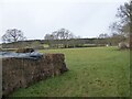
3
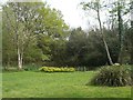
Pond by Nuthurst road
The pond at the end of a long field is obviously being well-tended.
In 1879 the field was part of Monk's common.
Ralph Vaughan Williams collected the song 'Our Captain cried all hands' from a Mrs Verrall of Monksgate in about 1904 and arranged John Bunyan's words from Pilgrim's Progress to produce 'He who would valiant be'. Check your hymn book and the tune is 'Monksgate'.
Image: © Peter Cox
Taken: 17 Apr 2007
0.04 miles
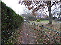
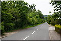
5
Nuthurst Road, Monks Gate
Heading west to the village of Nuthurst from the A281.
Image: © Simon Carey
Taken: 26 Dec 2023
0.06 miles
6
Nuthurst Road, Monk's Gate, Sussex
Seen from the junction with the A281, the village of Nuthurst is located a mile along this road.
Image: © Peter Trimming
Taken: 5 Jun 2010
0.06 miles
8
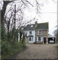
Thrift Cottage, Nuthurst Road, Monks Gate
Built in the late 19th century and set back from the road.
Image: © Simon Carey
Taken: 26 Dec 2023
0.07 miles
9
The Further Meadow
The name of the field according to Nuthurst's 1845 tithe map located to the west of Keystone Cottage.
Image: © Simon Carey
Taken: 26 Dec 2023
0.07 miles
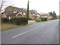
10
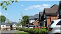
Houses on the south side of Nuthurst Road
Image: © Ian Hawfinch
Taken: 6 May 2020
0.07 miles