IMAGES TAKEN NEAR TO
Doomsday Lane, Coolhurst, HORSHAM, RH13 6LE
Introduction
This page details the photographs taken nearby to Doomsday Lane, Coolhurst, RH13 6LE by members of the Geograph project.
The Geograph project started in 2005 with the aim of publishing, organising and preserving representative images for every square kilometre of Great Britain, Ireland and the Isle of Man.

There are currently over 7.5m images from over14,400 individuals and you can help contribute to the project by visiting https://www.geograph.org.uk
Image Map
Images are licensed for reuse under creativecommons.org/licenses/by-sa/2.0
Notes
- Clicking on the map will re-center to the selected point.
- The higher the marker number, the further away the image location is from the centre of the postcode.
Image Listing (71 Images Found)
Images are licensed for reuse under creativecommons.org/licenses/by-sa/2.0
Image
Details
Distance
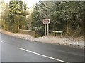
3
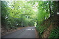
Doomsday Lane, Doomsday Green
It's Doomsday but it's still there.
Image: © David Howard
Taken: 30 Jan 2017
0.07 miles

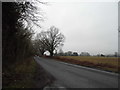
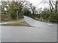
5
Doomsday Lane at the junction with Hammerpond Rd
Image: © N Chadwick
Taken: 2 May 2010
0.08 miles
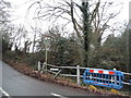
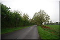
6
Bridge over the Horn Brook at Doomsday Green
Watch this space! The house in the trees is boarded up for demolition and planning permission for multiple housing has been sought.
Hammerpond Road links a number of hammer ponds on its way through Warninglid to Cuckfield. For more on hammer ponds see The Wealden Iron Research Group at http://www.wealdeniron.org.uk/
Image: © Peter Cox
Taken: 21 Dec 2007
0.08 miles

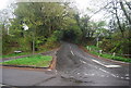
10
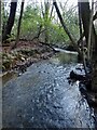
Horn Brook
A tributary of the River Arun that rises in Leechpool Wood and joins the Arun next to Kerves Lane.
Image: © Simon Carey
Taken: 26 Dec 2023
0.09 miles