IMAGES TAKEN NEAR TO
Kennedy Road, HORSHAM, RH13 5TG
Introduction
This page details the photographs taken nearby to Kennedy Road, RH13 5TG by members of the Geograph project.
The Geograph project started in 2005 with the aim of publishing, organising and preserving representative images for every square kilometre of Great Britain, Ireland and the Isle of Man.

There are currently over 7.5m images from over14,400 individuals and you can help contribute to the project by visiting https://www.geograph.org.uk
Image Map
Images are licensed for reuse under creativecommons.org/licenses/by-sa/2.0
Notes
- Clicking on the map will re-center to the selected point.
- The higher the marker number, the further away the image location is from the centre of the postcode.
Image Listing (113 Images Found)
Images are licensed for reuse under creativecommons.org/licenses/by-sa/2.0
Image
Details
Distance
5
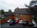
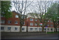
A wet morning in Horsham
Apartments just off the Brighton Road, Horsham.
Image: © Andrew Abbott
Taken: 21 Aug 2010
0.04 miles
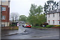
7
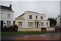
Appleyard House, Brighton Rd
A Victorian villa converted to offices.
Image: © N Chadwick
Taken: 2 May 2010
0.05 miles
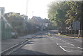
8
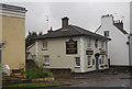
The Tanners Arms, Brighton Rd
An ex King & Barnes Pub, now a Hall & Woodhouse Pub.
Image: © N Chadwick
Taken: 2 May 2010
0.06 miles
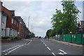
9
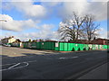
New development
Retirement homes to be built on the site of the former Clarence Road School. Corner of Brighton and Clarence Roads
Image: © The Saunterer
Taken: 2 Feb 2013
0.06 miles
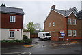
10
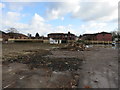
Demolition site
Site of former Clarence Road School
Image: © The Saunterer
Taken: 2 Feb 2013
0.06 miles