IMAGES TAKEN NEAR TO
Bennetts Road, HORSHAM, RH13 5JX
Introduction
This page details the photographs taken nearby to Bennetts Road, RH13 5JX by members of the Geograph project.
The Geograph project started in 2005 with the aim of publishing, organising and preserving representative images for every square kilometre of Great Britain, Ireland and the Isle of Man.

There are currently over 7.5m images from over14,400 individuals and you can help contribute to the project by visiting https://www.geograph.org.uk
Image Map (Loading...)


Getting Data...Please wait
Leaflet Map data © OpenStreetMap
Images are licensed for reuse under creativecommons.org/licenses/by-sa/2.0
Notes
- Clicking on the map will re-center to the selected point.
- The higher the marker number, the further away the image location is from the centre of the postcode.
Image Listing (55 Images Found)
Images are licensed for reuse under creativecommons.org/licenses/by-sa/2.0
Image
Details
Distance
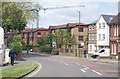
4
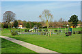
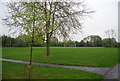
Bennett's Field play area
No play today, at least at 10:40 on a weekday morning.
Image: © Robin Webster
Taken: 13 Apr 2010
0.11 miles
5
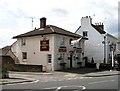
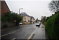
The Tanners Arms public house
At the junction of the Brighton Road and Arun Way.
Image: © Andy Potter
Taken: 8 May 2007
0.13 miles
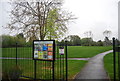
7
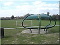
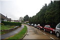
Bennetts field Youth shelter
The youth shelter has been placed at the east end of Bennetts field next to ball court and overlooking the sports field.
Image: © Peter Cox
Taken: 4 Apr 2007
0.13 miles
9
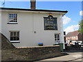
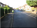
The Tanners Arms, Brighton Road (A281)
Eastern elevation at junction with Arun Way.
Image: © Peter Holmes
Taken: 28 Aug 2015
0.14 miles