IMAGES TAKEN NEAR TO
Queen Street, HORSHAM, RH13 5AF
Introduction
This page details the photographs taken nearby to Queen Street, RH13 5AF by members of the Geograph project.
The Geograph project started in 2005 with the aim of publishing, organising and preserving representative images for every square kilometre of Great Britain, Ireland and the Isle of Man.

There are currently over 7.5m images from over14,400 individuals and you can help contribute to the project by visiting https://www.geograph.org.uk
Image Map (Loading...)


Getting Data...Please wait
Leaflet Map data © OpenStreetMap
Images are licensed for reuse under creativecommons.org/licenses/by-sa/2.0
Notes
- Clicking on the map will re-center to the selected point.
- The higher the marker number, the further away the image location is from the centre of the postcode.
Image Listing (524 Images Found)
Images are licensed for reuse under creativecommons.org/licenses/by-sa/2.0
Image
Details
Distance

6
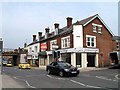
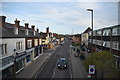
Closed shops in Queen Street
Seen between Image and Park Terrace East.
Image: © Andy Potter
Taken: 26 Apr 2007
0.02 miles
7
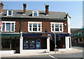
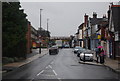
Closed no more!
One of the Image has a new tenant and its neighbour looks like it's been cleaned up prior to a new lease.
Image: © Andy Potter
Taken: 11 Aug 2007
0.02 miles

10
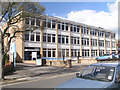
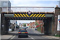
Inland Revenue offices
Formerly the offices for the DHSS (as it was then) in Queensway. This area, south of Queen Street used to be a brick field (where bricks were made).
Image: © Andy Potter
Taken: 1 Mar 2007
0.03 miles