IMAGES TAKEN NEAR TO
Six Acres, HORSHAM, RH13 0TH
Introduction
This page details the photographs taken nearby to Six Acres, RH13 0TH by members of the Geograph project.
The Geograph project started in 2005 with the aim of publishing, organising and preserving representative images for every square kilometre of Great Britain, Ireland and the Isle of Man.

There are currently over 7.5m images from over14,400 individuals and you can help contribute to the project by visiting https://www.geograph.org.uk
Image Map
Images are licensed for reuse under creativecommons.org/licenses/by-sa/2.0
Notes
- Clicking on the map will re-center to the selected point.
- The higher the marker number, the further away the image location is from the centre of the postcode.
Image Listing (50 Images Found)
Images are licensed for reuse under creativecommons.org/licenses/by-sa/2.0
Image
Details
Distance
2
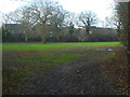
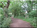
Footpath goes northwards from the Downs Link
The houses are on the edge of Slinfold.
See also http://www.geograph.org.uk/photo/1869546.
Image: © Shazz
Taken: 30 Jan 2016
0.09 miles
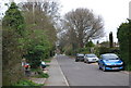
4
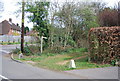
West Sussex Literary Trail off Hayes Lane
Image: © N Chadwick
Taken: 3 Apr 2011
0.11 miles
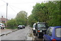
6
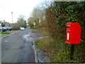
Looking north on Hayes Lane
Another picture of the postbox is at http://www.geograph.org.uk/photo/3366870.
Image: © Shazz
Taken: 30 Jan 2016
0.12 miles

10
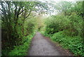
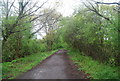
Downs Link approaching Slinfold
A view of the Downs Link path as it approaches Slinfold in West Sussex. The path follows a dismantled railway line. It also forms part of route 223 of the National Cycle Network.
Image: © Malc McDonald
Taken: 3 Jun 2022
0.13 miles