IMAGES TAKEN NEAR TO
Hayes Lane, HORSHAM, RH13 0SN
Introduction
This page details the photographs taken nearby to Hayes Lane, RH13 0SN by members of the Geograph project.
The Geograph project started in 2005 with the aim of publishing, organising and preserving representative images for every square kilometre of Great Britain, Ireland and the Isle of Man.

There are currently over 7.5m images from over14,400 individuals and you can help contribute to the project by visiting https://www.geograph.org.uk
Image Map (Loading...)


Getting Data...Please wait
Leaflet Map data © OpenStreetMap
Images are licensed for reuse under creativecommons.org/licenses/by-sa/2.0
Notes
- Clicking on the map will re-center to the selected point.
- The higher the marker number, the further away the image location is from the centre of the postcode.
Image Listing (14 Images Found)
Images are licensed for reuse under creativecommons.org/licenses/by-sa/2.0
Image
Details
Distance
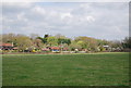
3
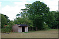
Llama house
This provided shelter for the two llamas in this field.
Image: © Robin Webster
Taken: 28 Jul 2010
0.13 miles
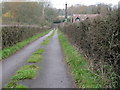
4
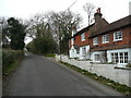
Pegtile cottages
By Hayes Lane, south of Slinfold.
Image: © Jonathan Billinger
Taken: 29 Jan 2008
0.14 miles
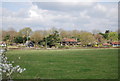
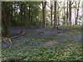
5
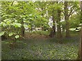
Chafers Copse
Chafers Copse with spring bluebells and a caravan in the background taken from the public footpath.
Image: © Chris Thomas-Atkin
Taken: 7 May 2017
0.16 miles

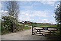
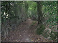
9
Minor road from Hayes Warren to Hayes Lane at the bottom
Image: © Dave Spicer
Taken: 21 Nov 2009
0.21 miles
10
Chafers Copse Bluebells
A spring day with the Bluebells in full flower.
Image: © Chris Thomas-Atkin
Taken: 7 May 2017
0.21 miles