IMAGES TAKEN NEAR TO
Park Street, HORSHAM, RH13 0RU
Introduction
This page details the photographs taken nearby to Park Street, RH13 0RU by members of the Geograph project.
The Geograph project started in 2005 with the aim of publishing, organising and preserving representative images for every square kilometre of Great Britain, Ireland and the Isle of Man.

There are currently over 7.5m images from over14,400 individuals and you can help contribute to the project by visiting https://www.geograph.org.uk
Image Map (Loading...)


Getting Data...Please wait
Leaflet Map data © OpenStreetMap
Images are licensed for reuse under creativecommons.org/licenses/by-sa/2.0
Notes
- Clicking on the map will re-center to the selected point.
- The higher the marker number, the further away the image location is from the centre of the postcode.
Image Listing (16 Images Found)
Images are licensed for reuse under creativecommons.org/licenses/by-sa/2.0
Image
Details
Distance
1
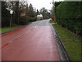
Park Street entering Slinfold from the A29
Image: © Dave Spicer
Taken: 14 Feb 2010
0.07 miles
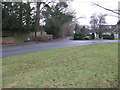
2
Park Street junction with the Roman Road Stane Street
Image: © Dave Spicer
Taken: 14 Feb 2010
0.10 miles
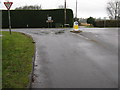
3
Bridleway junction with the A29 at Slinfold
Image: © Dave Spicer
Taken: 14 Feb 2010
0.11 miles
4
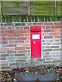
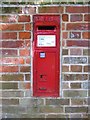
Postbox, Slinfold
The Victorian reign postbox is set into the wall of a house called Mullion. For a wider view Image
Image: © Maigheach-gheal
Taken: 25 Oct 2010
0.11 miles
5
Victorian GPO box, Slinfold
One of the smaller designs still to be found here and there. Compare Image , Image - or a tiny Edwardian example: Image
Image: © Stefan Czapski
Taken: 29 Sep 2012
0.11 miles
6
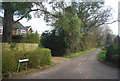
Road junction, Slinfold
The minor road twists and turns through the village. There is a Victorian postbox set into the wall.
Image: © Maigheach-gheal
Taken: 25 Oct 2010
0.11 miles
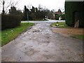
9
Spring Lane a cul-de-sac off Park Street Slinfold
Image: © Dave Spicer
Taken: 14 Feb 2010
0.12 miles
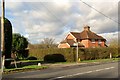
10
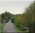
Looking south along the A29 (Stane Street)
The A29 follows the course of the Roman road (London to Chichester), The Random Hall hotel can be seen on the right.
Image: © N Chadwick
Taken: 2 May 2010
0.13 miles