IMAGES TAKEN NEAR TO
The Street, HORSHAM, RH13 0RR
Introduction
This page details the photographs taken nearby to The Street, RH13 0RR by members of the Geograph project.
The Geograph project started in 2005 with the aim of publishing, organising and preserving representative images for every square kilometre of Great Britain, Ireland and the Isle of Man.

There are currently over 7.5m images from over14,400 individuals and you can help contribute to the project by visiting https://www.geograph.org.uk
Image Map (Loading...)


Getting Data...Please wait
Leaflet Map data © OpenStreetMap
Images are licensed for reuse under creativecommons.org/licenses/by-sa/2.0
Notes
- Clicking on the map will re-center to the selected point.
- The higher the marker number, the further away the image location is from the centre of the postcode.
Image Listing (149 Images Found)
Images are licensed for reuse under creativecommons.org/licenses/by-sa/2.0
Image
Details
Distance
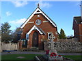
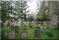
5
Looking out of Slinfold church
See also http://www.geograph.org.uk/photo/3872181 from 2014.
Image: © Shazz
Taken: 30 Jan 2016
0.02 miles
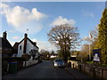
6
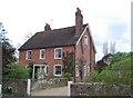
Stanford House
Grade II listed. http://www.britishlistedbuildings.co.uk/en-299590-stanford-house-slinfold
Image: © N Chadwick
Taken: 3 Apr 2011
0.02 miles
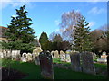
8
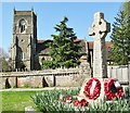
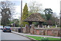
Slinfold - War Memorial
Celtic cross with poppy wreaths beside St Peter's, Slinfold's parish church.
Image: © Colin Smith
Taken: 9 Apr 2017
0.02 miles