IMAGES TAKEN NEAR TO
Five Oaks Road, HORSHAM, RH13 0RG
Introduction
This page details the photographs taken nearby to Five Oaks Road, RH13 0RG by members of the Geograph project.
The Geograph project started in 2005 with the aim of publishing, organising and preserving representative images for every square kilometre of Great Britain, Ireland and the Isle of Man.

There are currently over 7.5m images from over14,400 individuals and you can help contribute to the project by visiting https://www.geograph.org.uk
Image Map
Images are licensed for reuse under creativecommons.org/licenses/by-sa/2.0
Notes
- Clicking on the map will re-center to the selected point.
- The higher the marker number, the further away the image location is from the centre of the postcode.
Image Listing (19 Images Found)
Images are licensed for reuse under creativecommons.org/licenses/by-sa/2.0
Image
Details
Distance
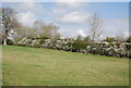
2
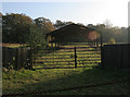
Disused barn
Opposite to Slinfold Manor, on the A264, facing south.
Image: © Chris Plunkett
Taken: 22 Nov 2005
0.06 miles
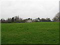
6
Slinfold Manor
Grade II listed. http://www.britishlistedbuildings.co.uk/en-299598-slinfold-manor-slinfold
Image: © N Chadwick
Taken: 3 Apr 2012
0.12 miles
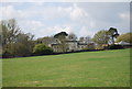
8
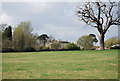
Slinfold Manor
Grade II listed. http://www.britishlistedbuildings.co.uk/en-299598-slinfold-manor-slinfold
Image: © N Chadwick
Taken: 3 Apr 2012
0.12 miles