IMAGES TAKEN NEAR TO
Lyons Farm Estate, Lyons Road, HORSHAM, RH13 0QP
Introduction
This page details the photographs taken nearby to Lyons Farm Estate, Lyons Road, RH13 0QP by members of the Geograph project.
The Geograph project started in 2005 with the aim of publishing, organising and preserving representative images for every square kilometre of Great Britain, Ireland and the Isle of Man.

There are currently over 7.5m images from over14,400 individuals and you can help contribute to the project by visiting https://www.geograph.org.uk
Image Map (Loading...)


Getting Data...Please wait
Leaflet Map data © OpenStreetMap
Images are licensed for reuse under creativecommons.org/licenses/by-sa/2.0
Notes
- Clicking on the map will re-center to the selected point.
- The higher the marker number, the further away the image location is from the centre of the postcode.
Image Listing (12 Images Found)
Images are licensed for reuse under creativecommons.org/licenses/by-sa/2.0
Image
Details
Distance
2
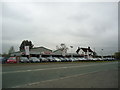
Motorline Toyota, Lyons Corner, Five Oaks Road, Horsham
Image: © Stacey Harris
Taken: 4 May 2012
0.08 miles
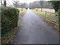
5
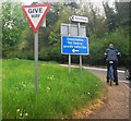
Lyons Corner
Lyons Lane meets Five Oak Road.
Image: © N Chadwick
Taken: 2 May 2010
0.10 miles
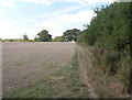
7
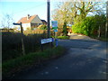
Junction of Pinkhurst Lane and Lyons Road
Pinkhurst Lane is a public footpath between lyons Road and the Downs Link.
Image: © Shazz
Taken: 30 Jan 2016
0.16 miles
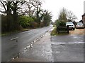
8
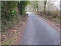
Cleared drainage ditches on Pinkhurst Lane
Image: © Dave Spicer
Taken: 14 Feb 2010
0.19 miles
10
Footpath 1450
Between footbridges at TQ138313 and TQ135312.
Image: © Andy Potter
Taken: 7 Sep 2006
0.23 miles