IMAGES TAKEN NEAR TO
Rye Farm Lane, HORSHAM, RH13 0QB
Introduction
This page details the photographs taken nearby to Rye Farm Lane, RH13 0QB by members of the Geograph project.
The Geograph project started in 2005 with the aim of publishing, organising and preserving representative images for every square kilometre of Great Britain, Ireland and the Isle of Man.

There are currently over 7.5m images from over14,400 individuals and you can help contribute to the project by visiting https://www.geograph.org.uk
Image Map (Loading...)


Getting Data...Please wait
Leaflet Map data © OpenStreetMap
Images are licensed for reuse under creativecommons.org/licenses/by-sa/2.0
Notes
- Clicking on the map will re-center to the selected point.
- The higher the marker number, the further away the image location is from the centre of the postcode.
Image Listing (26 Images Found)
Images are licensed for reuse under creativecommons.org/licenses/by-sa/2.0
Image
Details
Distance
1
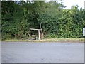
Public Footpath junction
FP1643 and FP1903
Image: © The Saunterer
Taken: 1 Apr 2013
0.02 miles
2
Footpath goes west from bridleway crossing
For a different view see http://www.geograph.org.uk/photo/3392159.
Image: © Shazz
Taken: 16 Dec 2016
0.03 miles
4
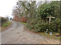
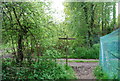
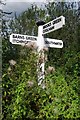
An interesting Fingerpost
The junction of Public Bridleway BW1616 and Public Footpath FP1643 (wellies, gnomes bird feeder & nesting box!)
Image: © The Saunterer
Taken: 1 Apr 2013
0.06 miles
5
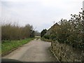
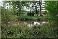
Footpath
Footpath at the end of Trout Lane. Leads back to Barns Green.
Image: © Matt Fisher esq
Taken: 22 Sep 2007
0.09 miles
9
Old Direction Sign - Signpost by Two Mile Ash Road, Itchingfield
Black iron cap finial - 3 arms; East Sussex wood by the UC road, in parish of Itchingfield (Horsham District), Two Mile Ash Road, well back from side of road opposite junction of Trout Lane with Two Mile Ash Road.
Surveyed
Milestone Society National ID: SX_TQ1326B
Image: © Milestone Society
Taken: Unknown
0.12 miles
10
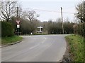
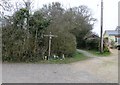
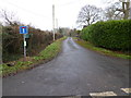
Road Junction
Trout Lane and Two Mile Ash Road
Image: © The Saunterer
Taken: 1 Apr 2013
0.12 miles