IMAGES TAKEN NEAR TO
Chapel Road, HORSHAM, RH13 0PR
Introduction
This page details the photographs taken nearby to Chapel Road, RH13 0PR by members of the Geograph project.
The Geograph project started in 2005 with the aim of publishing, organising and preserving representative images for every square kilometre of Great Britain, Ireland and the Isle of Man.

There are currently over 7.5m images from over14,400 individuals and you can help contribute to the project by visiting https://www.geograph.org.uk
Image Map (Loading...)


Getting Data...Please wait
Leaflet Map data © OpenStreetMap
Images are licensed for reuse under creativecommons.org/licenses/by-sa/2.0
Notes
- Clicking on the map will re-center to the selected point.
- The higher the marker number, the further away the image location is from the centre of the postcode.
Image Listing (47 Images Found)
Images are licensed for reuse under creativecommons.org/licenses/by-sa/2.0
Image
Details
Distance
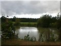
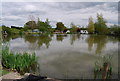
3
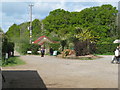
Entrance to Sumners Ponds
A camping and caravan site with their own fishing lakes
Image: © Dave Spicer
Taken: 2 May 2009
0.04 miles
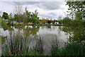
4
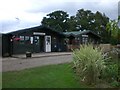
Shop and Cafe at Summers Ponds
Charming place to eat with views of the fishing lake.
Image: © Matt Fisher esq
Taken: 23 Sep 2007
0.05 miles
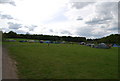
6
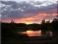
Sumners lake Barns Green
Sunset over the fishing lake.
Image: © Pam Goodey
Taken: 16 Aug 2007
0.08 miles