IMAGES TAKEN NEAR TO
Brooks Green, HORSHAM, RH13 0JU
Introduction
This page details the photographs taken nearby to RH13 0JU by members of the Geograph project.
The Geograph project started in 2005 with the aim of publishing, organising and preserving representative images for every square kilometre of Great Britain, Ireland and the Isle of Man.

There are currently over 7.5m images from over14,400 individuals and you can help contribute to the project by visiting https://www.geograph.org.uk
Image Map
Images are licensed for reuse under creativecommons.org/licenses/by-sa/2.0
Notes
- Clicking on the map will re-center to the selected point.
- The higher the marker number, the further away the image location is from the centre of the postcode.
Image Listing (8 Images Found)
Images are licensed for reuse under creativecommons.org/licenses/by-sa/2.0
Image
Details
Distance
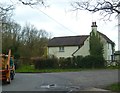
2
Post Box
RH13 57 Brook Green (Horsham)
Image: © The Saunterer
Taken: 8 Nov 2012
0.19 miles
4
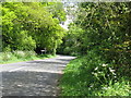
Public Footpath FP1907
0.824km in length off Emms Lane
Image: © The Saunterer
Taken: 1 Apr 2013
0.21 miles
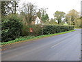
5
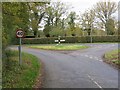
Road Junction
Lackenhurst Lane, Trout Lane and Coolham Road
Image: © The Saunterer
Taken: 8 Nov 2012
0.23 miles
6
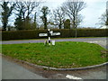
Signpost at the east end of Lackenhurst Lane
A similar view is at http://www.geograph.org.uk/photo/3216064.
Image: © Shazz
Taken: 15 Apr 2013
0.23 miles
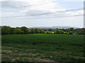
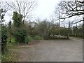
8
Reinstate the path
Looking across the large field from the point where public footpath number 1906 crosses to just to the left of the pylon ahead. The path through the crop has not been reinstated.
Image: © Chris Thomas-Atkin
Taken: 28 Jun 2020
0.25 miles