IMAGES TAKEN NEAR TO
Lackenhurst Lane, HORSHAM, RH13 0JL
Introduction
This page details the photographs taken nearby to Lackenhurst Lane, RH13 0JL by members of the Geograph project.
The Geograph project started in 2005 with the aim of publishing, organising and preserving representative images for every square kilometre of Great Britain, Ireland and the Isle of Man.

There are currently over 7.5m images from over14,400 individuals and you can help contribute to the project by visiting https://www.geograph.org.uk
Image Map
Images are licensed for reuse under creativecommons.org/licenses/by-sa/2.0
Notes
- Clicking on the map will re-center to the selected point.
- The higher the marker number, the further away the image location is from the centre of the postcode.
Image Listing (6 Images Found)
Images are licensed for reuse under creativecommons.org/licenses/by-sa/2.0
Image
Details
Distance
2
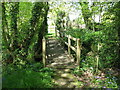
Friendly landowner leaves his mark
I've noticed this a few times recently. It must improve relationships between Landowners and walkers
Image: © Dave Spicer
Taken: 2 May 2009
0.06 miles
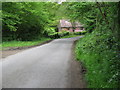
4
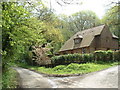
Junction house
This house is wedged in the triangular plot within the road junction.
Image: © Chris Shaw
Taken: 7 May 2006
0.21 miles
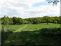
5
Looking north towards house that occupies the triangular piece of land where three roads meet
Image: © Dave Spicer
Taken: 2 May 2009
0.25 miles
6
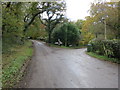
Lane Junction
Oldhouse Lane, Lackenhurst Lane and Baker's Lane
Image: © The Saunterer
Taken: 8 Nov 2012
0.25 miles