IMAGES TAKEN NEAR TO
Marlands Park, HORSHAM, RH13 0BF
Introduction
This page details the photographs taken nearby to Marlands Park, RH13 0BF by members of the Geograph project.
The Geograph project started in 2005 with the aim of publishing, organising and preserving representative images for every square kilometre of Great Britain, Ireland and the Isle of Man.

There are currently over 7.5m images from over14,400 individuals and you can help contribute to the project by visiting https://www.geograph.org.uk
Image Map (Loading...)


Getting Data...Please wait
Leaflet Map data © OpenStreetMap
Images are licensed for reuse under creativecommons.org/licenses/by-sa/2.0
Notes
- Clicking on the map will re-center to the selected point.
- The higher the marker number, the further away the image location is from the centre of the postcode.
Image Listing (6 Images Found)
Images are licensed for reuse under creativecommons.org/licenses/by-sa/2.0
Image
Details
Distance
1
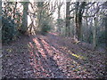
Bridleway south past perimeter fence of Marlands
Image: © Dave Spicer
Taken: 2 Jan 2010
0.12 miles
2
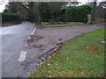
Plumtree Cross Lane towards Barns Green
On the right is the driveway for Storries
Image: © Dave Spicer
Taken: 21 Nov 2009
0.14 miles
3
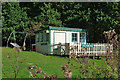
Marlands Halt
A summerhouse in the grounds of Marlands, got up to look like a station building. Unfortunately there was no sign of any railway in the vicinity.
Image: © Robin Webster
Taken: 22 Oct 2010
0.17 miles
4
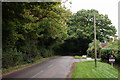
Plumtree Cross Lane
Located just north of Barns Green. There are footpaths to the left and right of the road at this location.
Image: © Peter Trimming
Taken: 13 Oct 2017
0.21 miles
5
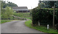
Barn on Marlands Home Farm, Barns Green
Seen from the junction of Plumtree Cross Lane and footpath 1615.
Image: © Andy Potter
Taken: 13 Sep 2006
0.21 miles
6
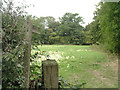
Footpath 1620
Seen from Plumtree Cross Lane.
Image: © Andy Potter
Taken: 13 Sep 2006
0.24 miles