
IMAGES TAKEN NEAR TO
The Kilns, REDHILL, RH1 2FY
Introduction
This page details the photographs taken nearby to The Kilns, RH1 2FY by members of the Geograph project.
The Geograph project started in 2005 with the aim of publishing, organising and preserving representative images for every square kilometre of Great Britain, Ireland and the Isle of Man.

There are currently over 7.5m images from over14,400 individuals and you can help contribute to the project by visiting https://www.geograph.org.uk
Image Map
Images are licensed for reuse under creativecommons.org/licenses/by-sa/2.0
Notes
- Clicking on the map will re-center to the selected point.
- The higher the marker number, the further away the image location is from the centre of the postcode.
Image Listing (104 Images Found)
Images are licensed for reuse under creativecommons.org/licenses/by-sa/2.0
Image
Details
Distance
1
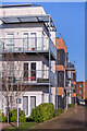
The Kilns
Apartment blocks in The Moors, part of Watercolour, a major housing development on the site of the old Holmethorpe sand quarry, built over the first 15 years or so of the 21st Century. These buildings were completed in 2014, the last part of the development.
Image: © Ian Capper
Taken: 17 Jan 2022
0.01 miles
2

5, 7 & 9 The Kilns
Part of a major housing development on the site of the old Holmethorpe sand quarry, marketed as Watercolour, built over the first 15 years or so of the 21st Century. These buildings are 5, 7 and 9 The Kilns, 3 apartment blocks in that road which were among the last buildings to be completed on the estate, in 2014.
Image: © Ian Capper
Taken: 17 Jan 2022
0.02 miles
3

Play area
Play area in Watercolour, a major housing development on the site of the old Holmethorpe sand quarry, built over the first 15 years or so of the 21st Century. In the background are 5 and 7 The Kilns, 2 out of 3 apartment blocks in that road which were among the last buildings to be completed on the estate, in 2014.
Image: © Ian Capper
Taken: 17 Jan 2022
0.03 miles
4

The Kilns
Part of a major housing development on the site of the old Holmethorpe sand quarry, marketed as Watercolour, built over the first 15 years or so of the 21st Century. The large building on the left is 9 The Kilns, one of 3 apartment blocks in that road which were among the last buildings to be completed on the estate, in 2014. On the right is Acorn Court, a care home opened in 2008.
Image: © Ian Capper
Taken: 17 Jan 2022
0.03 miles
5

Play area
Play area in Watercolour, a major housing development on the site of the old Holmethorpe sand quarry, built over the first 15 years or so of the 21st Century. In the background are 5 and 7 The Kilns, 2 out of 3 apartment blocks in that road which were among the last buildings to be completed on the estate, in 2014.
Image: © Ian Capper
Taken: 17 Jan 2022
0.04 miles
6

Watercolour
A major housing development on the site of the old Holmethorpe sand quarry, marketed as Watercolour, built over the first 15 years or so of the 21st Century. This is a view over the western part of the estate, with buildings in The Kilns, one of the last parts to be developed, on the left, and in The Moors on the right.
Image: © Ian Capper
Taken: 17 Jan 2022
0.04 miles
7

48 - 58 The Moors
Three pairs of semi-detached houses in The Moors, part of Watercolour, a major housing development on the site of the old Holmethorpe sand quarry, built over the first 15 years or so of the 21st Century. These buildings were completed in 2009/10.
Image: © Ian Capper
Taken: 17 Jan 2022
0.05 miles
8
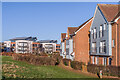
The Moors
Houses in The Moors, part of Watercolour, a major housing development on the site of the old Holmethorpe sand quarry, built over the first 15 years or so of the 21st Century. These buildings were completed in 2009/10. The blocks in the background are in The Kilns, competed in 2014.
Image: © Ian Capper
Taken: 17 Jan 2022
0.05 miles
9
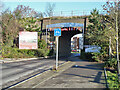
Trowers Way passes under the Quarry Line
The developments beyond were formerly the works of British Industrial Sand, and the bridge gave both road and rail access, the rail being connected to the Redhill Line.
Image: © Robin Webster
Taken: 16 Nov 2010
0.07 miles
10
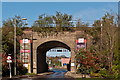
Canalside railway bridge
Originally road and rail access to the British Industrial Sand Holmethorpe Quarry under the Quarry Line (the section of the London-Brighton railway bypassing Redhill), this bridge now gives access from the west into the Watercolour housing development. beyond is the Holmethorpe Industrial Estate.
Image: © Ian Capper
Taken: 21 Apr 2012
0.07 miles