IMAGES TAKEN NEAR TO
Keats Close, HORSHAM, RH12 5PL
Introduction
This page details the photographs taken nearby to Keats Close, RH12 5PL by members of the Geograph project.
The Geograph project started in 2005 with the aim of publishing, organising and preserving representative images for every square kilometre of Great Britain, Ireland and the Isle of Man.

There are currently over 7.5m images from over14,400 individuals and you can help contribute to the project by visiting https://www.geograph.org.uk
Image Map
Images are licensed for reuse under creativecommons.org/licenses/by-sa/2.0
Notes
- Clicking on the map will re-center to the selected point.
- The higher the marker number, the further away the image location is from the centre of the postcode.
Image Listing (10 Images Found)
Images are licensed for reuse under creativecommons.org/licenses/by-sa/2.0
Image
Details
Distance


9
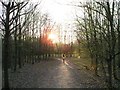
Sunset in man-made glade
This is in an strip of woodland created when the north of Horsham was developed. The hundreds of houses had a few corridors of trees planted around new streams.
Image: © Andy Potter
Taken: 10 Apr 2007
0.23 miles