IMAGES TAKEN NEAR TO
Parsonage Farm Industrial Estate, Parsonage Way, HORSHAM, RH12 4ZF
Introduction
This page details the photographs taken nearby to Parsonage Farm Industrial Estate, Parsonage Way, RH12 4ZF by members of the Geograph project.
The Geograph project started in 2005 with the aim of publishing, organising and preserving representative images for every square kilometre of Great Britain, Ireland and the Isle of Man.

There are currently over 7.5m images from over14,400 individuals and you can help contribute to the project by visiting https://www.geograph.org.uk
Image Map
Images are licensed for reuse under creativecommons.org/licenses/by-sa/2.0
Notes
- Clicking on the map will re-center to the selected point.
- The higher the marker number, the further away the image location is from the centre of the postcode.
Image Listing (22 Images Found)
Images are licensed for reuse under creativecommons.org/licenses/by-sa/2.0
Image
Details
Distance
3
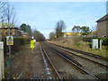
The railway going north towards Littlehaven station
This was taken from the level crossing on Parsonage Road.
Image: © Shazz
Taken: 29 Feb 2016
0.16 miles
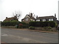
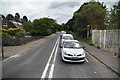
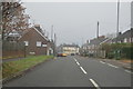
5
Parsonage Road at the junction of Foundry Lane
Image: © David Howard
Taken: 30 Jan 2017
0.18 miles
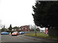
6
Closed shop in Rusper Road
This shop has been closed for over a year now. It looks like it was extended in the 1970s or 80s. The pillar box suggests that it may have had a sub post office.
Image: © Andy Potter
Taken: 13 Jun 2008
0.18 miles
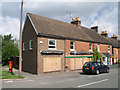
8
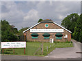
The Green Baize Billiards & Snooker Club
Next door but one to Image
Image: © Andy Potter
Taken: 13 Jun 2008
0.21 miles