IMAGES TAKEN NEAR TO
Tower Road, HORSHAM, RH12 4SX
Introduction
This page details the photographs taken nearby to Tower Road, RH12 4SX by members of the Geograph project.
The Geograph project started in 2005 with the aim of publishing, organising and preserving representative images for every square kilometre of Great Britain, Ireland and the Isle of Man.

There are currently over 7.5m images from over14,400 individuals and you can help contribute to the project by visiting https://www.geograph.org.uk
Image Map
Images are licensed for reuse under creativecommons.org/licenses/by-sa/2.0
Notes
- Clicking on the map will re-center to the selected point.
- The higher the marker number, the further away the image location is from the centre of the postcode.
Image Listing (18 Images Found)
Images are licensed for reuse under creativecommons.org/licenses/by-sa/2.0
Image
Details
Distance
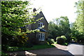
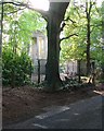
4
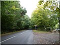
Exploring eastwards along the Bashire (32)
Tower Road
Image: © Basher Eyre
Taken: 7 Oct 2020
0.03 miles
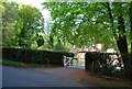
6
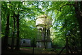
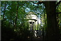
Water Tower, Beacon Hill, Colgate, West Sussex
This concrete water tower is built near to the highest point on Beacon Hill (146m above sea level). Colgate is situated on top of a long ridge of wealdland that stretches E-W between Pease Pottage and the outskirts of Horsham. Water pressure in the area would be quite low without the use of a water tower.
Image: © Pete Chapman
Taken: 13 Jul 2005
0.07 miles
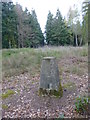
7
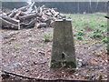
Ordnance Survey Trig Pillar S5160
This pillar can be found on Beacon Hill.
Image: © Peter Wood
Taken: 3 Apr 2012
0.10 miles