IMAGES TAKEN NEAR TO
Orltons Lane, HORSHAM, RH12 4RN
Introduction
This page details the photographs taken nearby to Orltons Lane, RH12 4RN by members of the Geograph project.
The Geograph project started in 2005 with the aim of publishing, organising and preserving representative images for every square kilometre of Great Britain, Ireland and the Isle of Man.

There are currently over 7.5m images from over14,400 individuals and you can help contribute to the project by visiting https://www.geograph.org.uk
Image Map
Images are licensed for reuse under creativecommons.org/licenses/by-sa/2.0
Notes
- Clicking on the map will re-center to the selected point.
- The higher the marker number, the further away the image location is from the centre of the postcode.
Image Listing (36 Images Found)
Images are licensed for reuse under creativecommons.org/licenses/by-sa/2.0
Image
Details
Distance
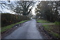
6
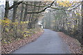
Gotwick Farm entrance
Not really an agricultural farm, although a lot of horse accommodation (also human accommodation). Currently up for sale, not cheap, but you get a lot for your money.
Image: © Robin Webster
Taken: 20 Dec 2009
0.06 miles
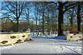
8
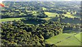
Countryside around Orltons Lane from the ait
With Orltons Copse in the foreground, and Gotwick Farm on the left.
Image: © Derek Harper
Taken: 3 Oct 2016
0.10 miles