IMAGES TAKEN NEAR TO
The Gardens, HORSHAM, RH12 3XP
Introduction
This page details the photographs taken nearby to The Gardens, RH12 3XP by members of the Geograph project.
The Geograph project started in 2005 with the aim of publishing, organising and preserving representative images for every square kilometre of Great Britain, Ireland and the Isle of Man.

There are currently over 7.5m images from over14,400 individuals and you can help contribute to the project by visiting https://www.geograph.org.uk
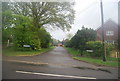
Image Map
Images are licensed for reuse under creativecommons.org/licenses/by-sa/2.0
Notes
- Clicking on the map will re-center to the selected point.
- The higher the marker number, the further away the image location is from the centre of the postcode.
Image Listing (135 Images Found)
Images are licensed for reuse under creativecommons.org/licenses/by-sa/2.0
Image
Details
Distance
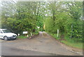
1
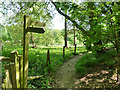
Footpath 1396, Rudgwick
Heading away from the village.
Image: © Robin Webster
Taken: 22 Apr 2011
0.06 miles
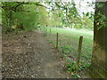
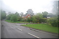
3
Footpath 1396, Rudgwick
Heading away from the village.
Image: © Robin Webster
Taken: 22 Apr 2011
0.10 miles
6
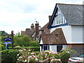
By the Chapel on Church Street
Rudgwick Rooflines beside Rudgwick Chapel. This stretch is residential, just downhill from the church.
Image: © Colin Smith
Taken: 13 Jun 2008
0.13 miles
7
Rudgwick Chapel
An evangelist chapel on Church Street.
Image: © Dave Spicer
Taken: 17 Apr 2011
0.14 miles
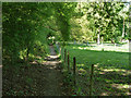
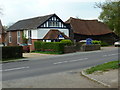
8
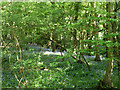
Gravatt's Hanger
Quite a lot of bluebells.
Image: © Robin Webster
Taken: 22 Apr 2011
0.14 miles
9
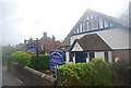
Rudgwick Chapel
An evangelical chapel founded in 1824.
Image: © N Chadwick
Taken: 2 May 2010
0.14 miles