IMAGES TAKEN NEAR TO
Southwater By Pass, HORSHAM, RH12 3UB
Introduction
This page details the photographs taken nearby to Southwater By Pass, RH12 3UB by members of the Geograph project.
The Geograph project started in 2005 with the aim of publishing, organising and preserving representative images for every square kilometre of Great Britain, Ireland and the Isle of Man.

There are currently over 7.5m images from over14,400 individuals and you can help contribute to the project by visiting https://www.geograph.org.uk
Image Map
Images are licensed for reuse under creativecommons.org/licenses/by-sa/2.0
Notes
- Clicking on the map will re-center to the selected point.
- The higher the marker number, the further away the image location is from the centre of the postcode.
Image Listing (58 Images Found)
Images are licensed for reuse under creativecommons.org/licenses/by-sa/2.0
Image
Details
Distance
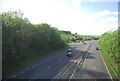
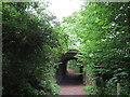
4
Footpath goes under the railway near Christ's Hospital station
Image: © N Chadwick
Taken: 2 May 2010
0.14 miles
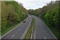
6
Downs Link at Christ's Hospital, near Horsham
A recently-opened section of the Downs Link, passing beneath the Arun Valley Line just north of Christ's Hospital station. The path also forms part of route 223 of the National Cycle Network.
Image: © Malc McDonald
Taken: 3 Jun 2022
0.15 miles
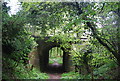
8

Tunnel under railway
Public Footpaths FP1628/2 & FP1628/3 meet under the Hossham to Billingshurst Line.
Image: © The Saunterer
Taken: 23 Feb 2013
0.15 miles
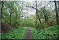
10
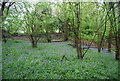
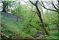
Bluebells in the woods near Christ's Hospital station
Image: © N Chadwick
Taken: 2 May 2010
0.15 miles