IMAGES TAKEN NEAR TO
The Forge, Byfleets Lane, HORSHAM, RH12 3UA
Introduction
This page details the photographs taken nearby to The Forge, Byfleets Lane, RH12 3UA by members of the Geograph project.
The Geograph project started in 2005 with the aim of publishing, organising and preserving representative images for every square kilometre of Great Britain, Ireland and the Isle of Man.

There are currently over 7.5m images from over14,400 individuals and you can help contribute to the project by visiting https://www.geograph.org.uk
Image Map
Images are licensed for reuse under creativecommons.org/licenses/by-sa/2.0
Notes
- Clicking on the map will re-center to the selected point.
- The higher the marker number, the further away the image location is from the centre of the postcode.
Image Listing (6 Images Found)
Images are licensed for reuse under creativecommons.org/licenses/by-sa/2.0
Image
Details
Distance
1
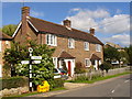
Letts Lane, Warnham
Cottages in a corner of Warnham, a West Sussex Wealden village near Horsham.
Image: © Colin Smith
Taken: 18 Sep 2010
0.04 miles
2
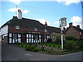
The Greets Inn
This much-altered 13th Century building on Friday Street, in the south of the square, has been a public house since around about the turn of the century.
Image: © Dan Gregory
Taken: 4 Sep 2007
0.12 miles
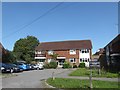
3
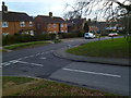
Houses on Tilletts Lane
The camera is near the junction with Gregsons.
Image: © Shazz
Taken: 21 Jan 2016
0.12 miles
4
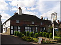
The Greets Inn, Warnham
Tile-hung pub on a lane off of the Warnham village main street.
http://www.british-history.ac.uk/report.aspx?compid=18360
Image: © Colin Smith
Taken: 18 Sep 2010
0.14 miles
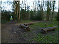
6
Exploring eastwards along the Bashire (25)
St Margaret's Court, Warnham
Image: © Basher Eyre
Taken: 18 Sep 2020
0.22 miles