IMAGES TAKEN NEAR TO
Pryors Wood, HORSHAM, RH12 3SZ
Introduction
This page details the photographs taken nearby to Pryors Wood, RH12 3SZ by members of the Geograph project.
The Geograph project started in 2005 with the aim of publishing, organising and preserving representative images for every square kilometre of Great Britain, Ireland and the Isle of Man.

There are currently over 7.5m images from over14,400 individuals and you can help contribute to the project by visiting https://www.geograph.org.uk
Image Map (Loading...)


Getting Data...Please wait
Leaflet Map data © OpenStreetMap
Images are licensed for reuse under creativecommons.org/licenses/by-sa/2.0
Notes
- Clicking on the map will re-center to the selected point.
- The higher the marker number, the further away the image location is from the centre of the postcode.
Image Listing (14 Images Found)
Images are licensed for reuse under creativecommons.org/licenses/by-sa/2.0
Image
Details
Distance
8
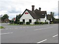
The Owl Kingsfold, not so clever now
Formerly called The Wise Old Owl.
Image: © Dave Spicer
Taken: 15 Jul 2012
0.09 miles
9
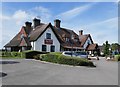
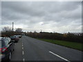
'The Owl' at Kingsfold
A bit of a landmark, standing at a junction on the A24.
Image: © Stefan Czapski
Taken: 30 Aug 2019
0.09 miles
10
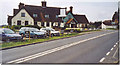
The Wise Old Owl, Kingsfold.
A quiet moment at this roadhouse on the busy A24 Dorking - Horsham road. The pub has almost certainly undergone a recent name change.
Image: © Colin Smith
Taken: Unknown
0.13 miles