IMAGES TAKEN NEAR TO
Dorking Road, HORSHAM, RH12 3QQ
Introduction
This page details the photographs taken nearby to Dorking Road, RH12 3QQ by members of the Geograph project.
The Geograph project started in 2005 with the aim of publishing, organising and preserving representative images for every square kilometre of Great Britain, Ireland and the Isle of Man.

There are currently over 7.5m images from over14,400 individuals and you can help contribute to the project by visiting https://www.geograph.org.uk
Image Map
Images are licensed for reuse under creativecommons.org/licenses/by-sa/2.0
Notes
- Clicking on the map will re-center to the selected point.
- The higher the marker number, the further away the image location is from the centre of the postcode.
Image Listing (13 Images Found)
Images are licensed for reuse under creativecommons.org/licenses/by-sa/2.0
Image
Details
Distance

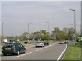
5
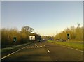
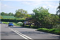
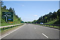
A264 approaching the Great Daux roundabout
Image: © Elliott Simpson
Taken: 16 Feb 2016
0.11 miles
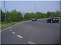
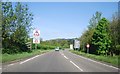
8
Great Daux roundabout
At the junction of the A24 and A264 seen from the end of the old Worthing road. This roundabout is named after the nearby Great Daux farm. The 1880 map spelling was Great Dorks so that should end the confusion as to whether it is pronounced 'Dawks' or 'Doe'!
Image: © Andy Potter
Taken: 17 Apr 2007
0.14 miles