IMAGES TAKEN NEAR TO
Pelling Way, HORSHAM, RH12 3GW
Introduction
This page details the photographs taken nearby to Pelling Way, RH12 3GW by members of the Geograph project.
The Geograph project started in 2005 with the aim of publishing, organising and preserving representative images for every square kilometre of Great Britain, Ireland and the Isle of Man.

There are currently over 7.5m images from over14,400 individuals and you can help contribute to the project by visiting https://www.geograph.org.uk
Image Map
Images are licensed for reuse under creativecommons.org/licenses/by-sa/2.0
Notes
- Clicking on the map will re-center to the selected point.
- The higher the marker number, the further away the image location is from the centre of the postcode.
Image Listing (19 Images Found)
Images are licensed for reuse under creativecommons.org/licenses/by-sa/2.0
Image
Details
Distance
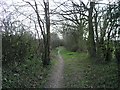
5
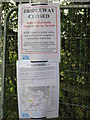
Public Bridleway BW1630
Temporarily closed whilst housing is under construction
Image: © The Saunterer
Taken: 14 Sep 2012
0.14 miles
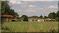
6
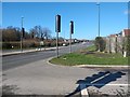
Looking West along the A264 from old Wickhurst Lane
Image: © Thoma
Taken: 16 Mar 2020
0.15 miles
7
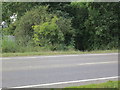
Public Bridleway BW1630
Crosses the A264 (Broadbridge Heath By-Pass)
Image: © The Saunterer
Taken: 14 Sep 2012
0.15 miles
8
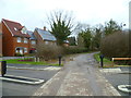
Looking north across junction on Old Wickhurst Lane
I believe the new crossing road is Cook Way.
Image: © Shazz
Taken: 26 Jan 2016
0.15 miles
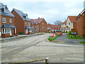
9
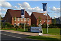
New homes and flags at Wickhurst Green
Major new housing development on the edge of Broadbridge Heath.
Image: © David Martin
Taken: 10 Aug 2014
0.16 miles
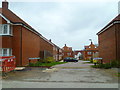
10
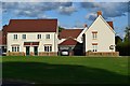
New housing at Wickhurst Green
Major new housing development on the edge of Broadbridge Heath.
Image: © David Martin
Taken: 10 Aug 2014
0.17 miles