IMAGES TAKEN NEAR TO
Langridge Lane, HORSHAM, RH12 3GP
Introduction
This page details the photographs taken nearby to Langridge Lane, RH12 3GP by members of the Geograph project.
The Geograph project started in 2005 with the aim of publishing, organising and preserving representative images for every square kilometre of Great Britain, Ireland and the Isle of Man.

There are currently over 7.5m images from over14,400 individuals and you can help contribute to the project by visiting https://www.geograph.org.uk
Image Map
Images are licensed for reuse under creativecommons.org/licenses/by-sa/2.0
Notes
- Clicking on the map will re-center to the selected point.
- The higher the marker number, the further away the image location is from the centre of the postcode.
Image Listing (14 Images Found)
Images are licensed for reuse under creativecommons.org/licenses/by-sa/2.0
Image
Details
Distance
1
Entrance to Newbridge Nurseries, Broadbridge Heath
Image: © nick macneill
Taken: 21 Jan 2011
0.07 miles
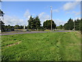
3
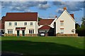
New housing at Wickhurst Green
Major new housing development on the edge of Broadbridge Heath.
Image: © David Martin
Taken: 10 Aug 2014
0.11 miles
4

New homes and flags at Wickhurst Green
Major new housing development on the edge of Broadbridge Heath.
Image: © David Martin
Taken: 10 Aug 2014
0.11 miles
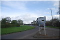
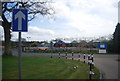
6
Road junction at the roundabout
The A281 meets the A264 and Billingshurst Road
Image: © The Saunterer
Taken: 14 Sep 2012
0.13 miles
7
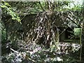
Anti-tank pill box hidden in undergrowth
This type 28 pill box was built to defend Image
Image: © Andy Potter
Taken: 2 May 2007
0.16 miles
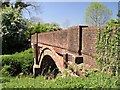
8
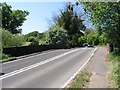
New Bridge on the Five Oaks Road
The road from Broadbridge Heath to Slinfold and Billingshurst existed in 1347 but first mention of a bridge on this site was in 1615. I think this bridge is 'New' when compared to Image In this view, looking west, the left hand side of the bridge is a brick arch with the right hand side being a reinforced concrete slab. The matching brick parapets would have been built at the time of the widening.
Image: © Andy Potter
Taken: 2 May 2007
0.20 miles
9
South view of Newbridge
The contrast between the newer dark brick of the parapet and the red of the original span is clear. Also visible are the remains of a 4 inch metal pipe and its supporting brackets.
Image: © Andy Potter
Taken: 2 May 2007
0.20 miles