IMAGES TAKEN NEAR TO
Cooks Hill, HORSHAM, RH12 3BB
Introduction
This page details the photographs taken nearby to Cooks Hill, RH12 3BB by members of the Geograph project.
The Geograph project started in 2005 with the aim of publishing, organising and preserving representative images for every square kilometre of Great Britain, Ireland and the Isle of Man.

There are currently over 7.5m images from over14,400 individuals and you can help contribute to the project by visiting https://www.geograph.org.uk
Image Map
Images are licensed for reuse under creativecommons.org/licenses/by-sa/2.0
Notes
- Clicking on the map will re-center to the selected point.
- The higher the marker number, the further away the image location is from the centre of the postcode.
Image Listing (10 Images Found)
Images are licensed for reuse under creativecommons.org/licenses/by-sa/2.0
Image
Details
Distance
1
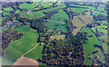
Woods and farmland west of Rudgwick from the air
The wood in the foreground is Well Grove. Lynwick Farm is in the centre, with Woodsomes Farm to the left. The prominent road on the right is the A281. The edge of Rudgwick is in the top left corner.
Image: © Derek Harper
Taken: 18 Oct 2018
0.05 miles
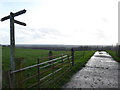
2
A good view
All the better for being the first bright day for a long time.
Image: © Shazz
Taken: 23 Dec 2015
0.10 miles
3
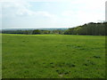
View south from the border between Surrey and Sussex
Below is the Low Weald and on a clear day the South Downs would be visible.
Image: © Dave Spicer
Taken: 17 Apr 2011
0.13 miles
5
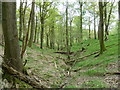
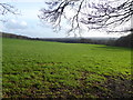
Private woodland
These woods surround a property called Well Grove.
Image: © Dave Spicer
Taken: 17 Apr 2011
0.21 miles
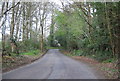
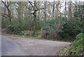
6
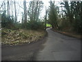
Cooks Hill by the track to Lynwick and beyond
This is just over the border from Surrey into Sussex.
Image: © David Howard
Taken: 26 Feb 2012
0.23 miles
7
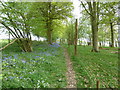
Deer fence by the Sussex Border Path
It appears that bluebells favour the Surrey side.
Image: © Dave Spicer
Taken: 17 Apr 2011
0.23 miles
9
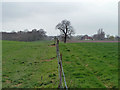
On the county border
Unusually the Sussex Border Path runs very close to the actual border here, in this case with Surrey, which is to the right of the fence. Strictly speaking, the tree ahead is probably on the historic border, but one guesses the fence line is taken as the border for practical purposes now.
Image: © Robin Webster
Taken: 31 Mar 2011
0.25 miles