IMAGES TAKEN NEAR TO
Furzen Lane, HORSHAM, RH12 3AP
Introduction
This page details the photographs taken nearby to Furzen Lane, RH12 3AP by members of the Geograph project.
The Geograph project started in 2005 with the aim of publishing, organising and preserving representative images for every square kilometre of Great Britain, Ireland and the Isle of Man.

There are currently over 7.5m images from over14,400 individuals and you can help contribute to the project by visiting https://www.geograph.org.uk
Image Map
Images are licensed for reuse under creativecommons.org/licenses/by-sa/2.0
Notes
- Clicking on the map will re-center to the selected point.
- The higher the marker number, the further away the image location is from the centre of the postcode.
Image Listing (9 Images Found)
Images are licensed for reuse under creativecommons.org/licenses/by-sa/2.0
Image
Details
Distance
1
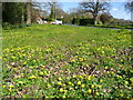
Carpet of celandine
A wide verge by Furzen Lane, looking east.
Image: © Jonathan Billinger
Taken: 17 Apr 2008
0.02 miles
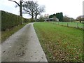
2
Tree lined bridleway to Furzen Lane
At Ellens Green.
Image: © Dave Spicer
Taken: 4 Dec 2011
0.05 miles
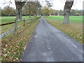
3
Furzen Lane on the outskirts of Ellen's Green
Image: © Dave Spicer
Taken: 4 Dec 2011
0.06 miles
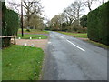
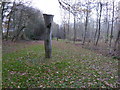
4
Trees by Furzen Lane
This is near the entrance to Bury St. Austen's to the east of Ellen's Green.
Image: © Jonathan Billinger
Taken: 17 Apr 2008
0.06 miles
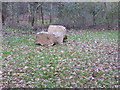
5
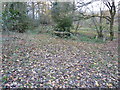
Footbridge and decaying tree on path to Polingfold Copse
Image: © Dave Spicer
Taken: 4 Dec 2011
0.09 miles
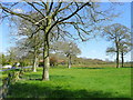
8
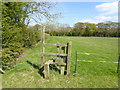
Looking across field north of Furzen Lane from stile
Image: © Shazz
Taken: 12 Apr 2017
0.20 miles