IMAGES TAKEN NEAR TO
Lawns Road, HORSHAM, RH12 3AE
Introduction
This page details the photographs taken nearby to Lawns Road, RH12 3AE by members of the Geograph project.
The Geograph project started in 2005 with the aim of publishing, organising and preserving representative images for every square kilometre of Great Britain, Ireland and the Isle of Man.

There are currently over 7.5m images from over14,400 individuals and you can help contribute to the project by visiting https://www.geograph.org.uk
Image Map
Images are licensed for reuse under creativecommons.org/licenses/by-sa/2.0
Notes
- Clicking on the map will re-center to the selected point.
- The higher the marker number, the further away the image location is from the centre of the postcode.
Image Listing (42 Images Found)
Images are licensed for reuse under creativecommons.org/licenses/by-sa/2.0
Image
Details
Distance
1
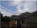
Bungalow on Lawns Road, Baynards
This appears to be a holiday chalet and has a sports field next to it.
Image: © David Howard
Taken: 13 Sep 2015
0.02 miles
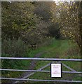
3
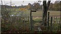
Stile on Lawns Road
There has been a lot of rain and the field is waterlogged.
Image: © Shazz
Taken: 16 Nov 2009
0.04 miles

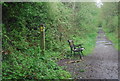
7
Ornamental cast iron seat on the Downs Link
The footpath to the left connects with Knowle Lane near Ivelle Farm.
Image: © Dave Spicer
Taken: 5 Nov 2011
0.07 miles
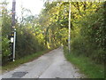
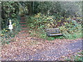
9
Mounting block on bridleway
This is immediately to the north of Lawns Road.
Image: © Shazz
Taken: 16 Nov 2009
0.08 miles
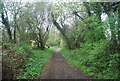
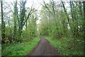
10
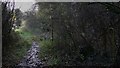
Bridleway leading to Lawns Road
This is just north of the end of Lawns Road and there is a footpath through the woods to the right.
Image: © Shazz
Taken: 16 Nov 2009
0.09 miles