IMAGES TAKEN NEAR TO
Trundle Mead, HORSHAM, RH12 2LY
Introduction
This page details the photographs taken nearby to Trundle Mead, RH12 2LY by members of the Geograph project.
The Geograph project started in 2005 with the aim of publishing, organising and preserving representative images for every square kilometre of Great Britain, Ireland and the Isle of Man.

There are currently over 7.5m images from over14,400 individuals and you can help contribute to the project by visiting https://www.geograph.org.uk
Image Map
Images are licensed for reuse under creativecommons.org/licenses/by-sa/2.0
Notes
- Clicking on the map will re-center to the selected point.
- The higher the marker number, the further away the image location is from the centre of the postcode.
Image Listing (12 Images Found)
Images are licensed for reuse under creativecommons.org/licenses/by-sa/2.0
Image
Details
Distance
1
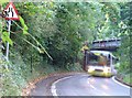
Railway bridge in suburban Horsham, West Sussex
Service bus approaching! A long exposure due to dim light - they don't all drive as fast as this looks! Viewed from the N, looking S. The railway line links Horsham to Dorking.
Image: © Pete Chapman
Taken: 30 Sep 2005
0.02 miles
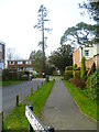
2
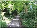
Bridleway near the centre of Horsham
The short bridleway connects Pondtail Road with North Heath Lane.
Image: © Dave Spicer
Taken: 15 Jul 2012
0.08 miles
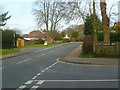
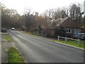
7
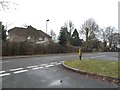
Pondtail Road at the junction of Old Millmeads
Image: © David Howard
Taken: 30 Jan 2017
0.15 miles
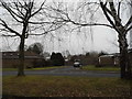
10
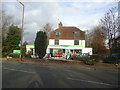
The Co-operative, Warnham Road, Horsham
Image: © Stacey Harris
Taken: 26 Nov 2011
0.23 miles