IMAGES TAKEN NEAR TO
Curzon Avenue, HORSHAM, RH12 2LA
Introduction
This page details the photographs taken nearby to Curzon Avenue, RH12 2LA by members of the Geograph project.
The Geograph project started in 2005 with the aim of publishing, organising and preserving representative images for every square kilometre of Great Britain, Ireland and the Isle of Man.

There are currently over 7.5m images from over14,400 individuals and you can help contribute to the project by visiting https://www.geograph.org.uk
Image Map
Images are licensed for reuse under creativecommons.org/licenses/by-sa/2.0
Notes
- Clicking on the map will re-center to the selected point.
- The higher the marker number, the further away the image location is from the centre of the postcode.
Image Listing (88 Images Found)
Images are licensed for reuse under creativecommons.org/licenses/by-sa/2.0
Image
Details
Distance
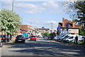
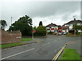
1
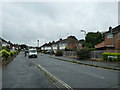
Streets of Horsham
Junction of Curzon Avenue and Vale Drive.
Image: © James Emmans
Taken: 4 Jun 2022
0.08 miles
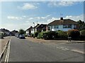
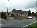
2
Church of Christ, Scientist
At the junction of Black Bridge Lane and the Guildford Road this church was first registered in 1953.
Image: © Andy Potter
Taken: 17 Jul 2007
0.09 miles
5
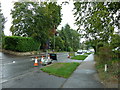
Temporary traffic lights in Guildford Road
Image: © Basher Eyre
Taken: 22 Aug 2010
0.11 miles
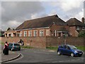
6
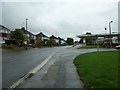
Approaching the junction of Blackbridge Lane and Guildford Road
Image: © Basher Eyre
Taken: 22 Aug 2010
0.11 miles
8
Looking from Blackbridge Lane into Guildford Road
Image: © Basher Eyre
Taken: 22 Aug 2010
0.11 miles
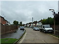
9
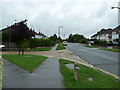
Approaching the junction of Greenway and Farm Avenue
Image: © Basher Eyre
Taken: 22 Aug 2010
0.12 miles