IMAGES TAKEN NEAR TO
Saxon Crescent, HORSHAM, RH12 2HU
Introduction
This page details the photographs taken nearby to Saxon Crescent, RH12 2HU by members of the Geograph project.
The Geograph project started in 2005 with the aim of publishing, organising and preserving representative images for every square kilometre of Great Britain, Ireland and the Isle of Man.

There are currently over 7.5m images from over14,400 individuals and you can help contribute to the project by visiting https://www.geograph.org.uk
Image Map
Images are licensed for reuse under creativecommons.org/licenses/by-sa/2.0
Notes
- Clicking on the map will re-center to the selected point.
- The higher the marker number, the further away the image location is from the centre of the postcode.
Image Listing (58 Images Found)
Images are licensed for reuse under creativecommons.org/licenses/by-sa/2.0
Image
Details
Distance
1
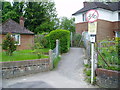
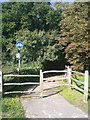
Path to allotments
Footpath from Albery Close to Spencers Place and allotments.
Image: © Peter Holmes
Taken: 17 May 2012
0.05 miles
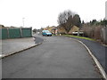
5
Twitten at Clippers
Public footpath 1582 from Spencers Place to Albery Close.
Image: © Peter Holmes
Taken: 17 May 2012
0.09 miles
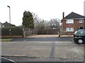
7
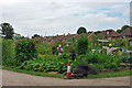
Scarecrows on the allotments
With scarecrow help, there is impressive growth on Shelley Allotments, Horsham.
Image: © Robin Webster
Taken: 30 Jul 2010
0.10 miles
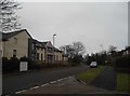
10
Path to golf course
Shared use bike/footpath.
Image: © Matt Ellery
Taken: 10 Oct 2010
0.11 miles