IMAGES TAKEN NEAR TO
Arundale Walk, HORSHAM, RH12 1QG
Introduction
This page details the photographs taken nearby to Arundale Walk, RH12 1QG by members of the Geograph project.
The Geograph project started in 2005 with the aim of publishing, organising and preserving representative images for every square kilometre of Great Britain, Ireland and the Isle of Man.

There are currently over 7.5m images from over14,400 individuals and you can help contribute to the project by visiting https://www.geograph.org.uk
Image Map
Images are licensed for reuse under creativecommons.org/licenses/by-sa/2.0
Notes
- Clicking on the map will re-center to the selected point.
- The higher the marker number, the further away the image location is from the centre of the postcode.
Image Listing (9 Images Found)
Images are licensed for reuse under creativecommons.org/licenses/by-sa/2.0
Image
Details
Distance
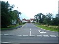
1
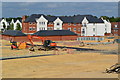
New housing development on the edge of Horsham
Seen from the new junction above the A24
Image: © David Martin
Taken: 21 Jun 2015
0.04 miles
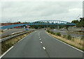
4
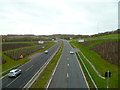
Looking south on the A24 from the new bridge at Broadbridge Heath
Image: © Shazz
Taken: 26 Jan 2016
0.14 miles
6
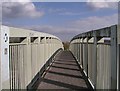
Footbridge over the A24
This bridge connects Tanbridge School and the Broadbridge Heath Leisure Centre. To give you an idea of size it is about 1.5m wide and the parapet is about 2m high.
Image: © Andy Potter
Taken: 10 Apr 2007
0.22 miles
7
Skirting Horsham
The A24 passing between Horsham and Broadbridge Heath. Seen from a passing coach.
Image: © Martin Addison
Taken: 11 Aug 2018
0.23 miles
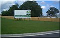
8
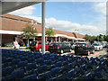
Tesco, Broadbridge Heath
In Old Wickhurst Lane.
Image: © Andy Potter
Taken: 8 Sep 2006
0.24 miles
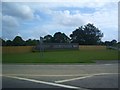
9
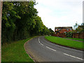
Hills Farm Lane, Horsham
This estate was built on the site of former farmlands as remembered in the street name. Behind the trees on the left is the River Arun. This view looks north.
Image: © Simon Carey
Taken: 22 Oct 2005
0.24 miles