IMAGES TAKEN NEAR TO
Albion Way, HORSHAM, RH12 1JW
Introduction
This page details the photographs taken nearby to Albion Way, RH12 1JW by members of the Geograph project.
The Geograph project started in 2005 with the aim of publishing, organising and preserving representative images for every square kilometre of Great Britain, Ireland and the Isle of Man.

There are currently over 7.5m images from over14,400 individuals and you can help contribute to the project by visiting https://www.geograph.org.uk
Image Map
Images are licensed for reuse under creativecommons.org/licenses/by-sa/2.0
Notes
- Clicking on the map will re-center to the selected point.
- The higher the marker number, the further away the image location is from the centre of the postcode.
Image Listing (651 Images Found)
Images are licensed for reuse under creativecommons.org/licenses/by-sa/2.0
Image
Details
Distance

3

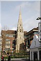
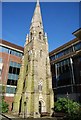
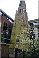
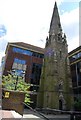
St Mary, Horsham: stained glass windows (10)
Image: © Basher Eyre
Taken: 22 Aug 2010
0.01 miles
5
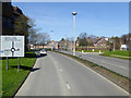
Horsham partial ring road
This links routes radiating from the town to nominally east, north, west and south, but the south - east part is missing.
Image: © Robin Webster
Taken: 18 Apr 2018
0.02 miles