IMAGES TAKEN NEAR TO
Calvert Link, HORSHAM, RH12 0AF
Introduction
This page details the photographs taken nearby to Calvert Link, RH12 0AF by members of the Geograph project.
The Geograph project started in 2005 with the aim of publishing, organising and preserving representative images for every square kilometre of Great Britain, Ireland and the Isle of Man.

There are currently over 7.5m images from over14,400 individuals and you can help contribute to the project by visiting https://www.geograph.org.uk
Image Map
Images are licensed for reuse under creativecommons.org/licenses/by-sa/2.0
Notes
- Clicking on the map will re-center to the selected point.
- The higher the marker number, the further away the image location is from the centre of the postcode.
Image Listing (79 Images Found)
Images are licensed for reuse under creativecommons.org/licenses/by-sa/2.0
Image
Details
Distance
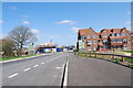
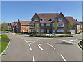
1
Calvert Link, Kilnwood Vale
A completed part of this new development.
Image: © Robin Webster
Taken: 18 Apr 2018
0.04 miles
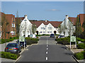
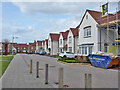
2
Housing on Calvert Link, Kilnwood Vale
Kilnwood Vale is a new development stuck on the west side of Crawley, but in Horsham District.
Image: © Robin Webster
Taken: 27 Mar 2021
0.04 miles
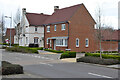
3
Houses, Kilnwood Vale
A completed part of this new development.
Image: © Robin Webster
Taken: 18 Apr 2018
0.06 miles
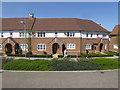
4
In Kilnwood Vale
A new development built on a rubbish dump. A view from a 23 bus which at the moment has to reverse into the road on the right to return to the main road the way it came. Presumably a more satisfactory route is intended as the development progresses.
Image: © Robin Webster
Taken: 18 Apr 2018
0.06 miles
5
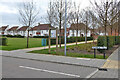
North end of Kilnwood Vale Neighbourhood Park
So called on the board, Rainbow Field refers to the road, Bushy Field is on the other side. Kilnwood Vale is a new development stuck on the west side of Crawley, but in Horsham District.
Image: © Robin Webster
Taken: 27 Mar 2021
0.06 miles
6
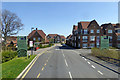
Kilnwood Vale
A new development built on a rubbish dump. A view from a 23 bus which at the moment has to reverse at the far junction to return to the main road. Presumably a more satisfactory route is intended as the development progresses.
Image: © Robin Webster
Taken: 18 Apr 2018
0.07 miles
7
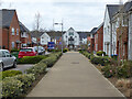
Brickyard Way, Kilnwood Vale
Kilnwood Vale is a new development stuck on the west side of Crawley, but in Horsham District.
Image: © Robin Webster
Taken: 27 Mar 2021
0.08 miles
8
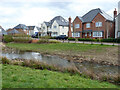
Houses overlooking Attenuation Pond, Kilnwood Vale
They are on Brickyard Way. Kilnwood Vale is a new development stuck on the west side of Crawley, but in Horsham District.
Image: © Robin Webster
Taken: 27 Mar 2021
0.08 miles
9
Houses on Rainbow Field, Kilnwood Vale
Kilnwood Vale is a new development stuck on the west side of Crawley, but in Horsham District.
Image: © Robin Webster
Taken: 27 Mar 2021
0.08 miles