IMAGES TAKEN NEAR TO
RH1 1RZ
Introduction
This page details the photographs taken nearby to RH1 1RZ by members of the Geograph project.
The Geograph project started in 2005 with the aim of publishing, organising and preserving representative images for every square kilometre of Great Britain, Ireland and the Isle of Man.

There are currently over 7.5m images from over14,400 individuals and you can help contribute to the project by visiting https://www.geograph.org.uk
Image Map
Images are licensed for reuse under creativecommons.org/licenses/by-sa/2.0
Notes
- Clicking on the map will re-center to the selected point.
- The higher the marker number, the further away the image location is from the centre of the postcode.
Image Listing (574 Images Found)
Images are licensed for reuse under creativecommons.org/licenses/by-sa/2.0
Image
Details
Distance
1
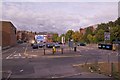
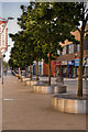
Marketfield Car Park
A council operated open air car park between High Street and Marketfield Way.
Image: © Ian Capper
Taken: 29 Aug 2011
0.00 miles
2
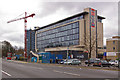
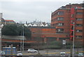
RedCentral and Kingsgate, Redhill
A view of these offices from the north east (see Image for info), with the Marketfield carpark in the foreground.
Image: © Ian Capper
Taken: 23 Mar 2008
0.03 miles
3
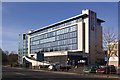
RedCentral and Kingsgate
Viewed from Marketfield Way. Compare Image, taken when Kingsgate was still under construction.
Image: © Ian Capper
Taken: 15 Mar 2009
0.03 miles
4
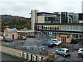
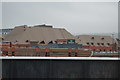
Rooftops, Redhill
Looking south-east from the Belfry roof car park.
Image: © Robin Webster
Taken: 17 Nov 2010
0.03 miles
6
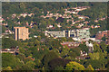
Redhill from Reigate Hill
Looking towards central Redhill from Reigate Hill. Prominent features are the Dome on the left (see Image) and the Redhill town centre office buildings of RedCentral and Kingsgate to its right. Behind is Redstone Hill and in the bottom right hand corner is Wray Common Windmill (see Image).
Image: © Ian Capper
Taken: 29 Jun 2018
0.04 miles
8
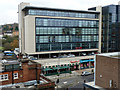
High Street building, Redhill
Part of the Redcentral office block.
Image: © Robin Webster
Taken: 17 Nov 2010
0.04 miles
9
Redhill High Street
The High Street looking northward
Image: © Kurseong Carl
Taken: 4 Jul 2010
0.04 miles
10
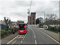
Bus stand on A23, Redhill
Necessary because the bus station has no room for layovers of terminating services. Route 405 is a TfL tentacle reaching out of London with a Croydon - Redhill service.
Image: © Robin Webster
Taken: 23 Mar 2019
0.04 miles