IMAGES TAKEN NEAR TO
Chapel Road, REDHILL, RH1 1HH
Introduction
This page details the photographs taken nearby to Chapel Road, RH1 1HH by members of the Geograph project.
The Geograph project started in 2005 with the aim of publishing, organising and preserving representative images for every square kilometre of Great Britain, Ireland and the Isle of Man.

There are currently over 7.5m images from over14,400 individuals and you can help contribute to the project by visiting https://www.geograph.org.uk
Image Map
Images are licensed for reuse under creativecommons.org/licenses/by-sa/2.0
Notes
- Clicking on the map will re-center to the selected point.
- The higher the marker number, the further away the image location is from the centre of the postcode.
Image Listing (441 Images Found)
Images are licensed for reuse under creativecommons.org/licenses/by-sa/2.0
Image
Details
Distance
1
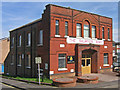
Salvation Army Citadel
At the junction of Sincots Road (on the left) and Lower Bridge Street (on the right). Dating from 1890, when this area consisted of terraced housing, now replaced by the Cromwell Road housing estate, buildings of which can be seen in the background on both sides of the citadel.
Image: © Ian Capper
Taken: 26 Apr 2008
0.03 miles
2
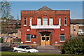
Salvation Army Citadel
Dating from 1890, when this area consisted of terraced housing, now replaced by the Cromwell Road housing estate, buildings of which can be seen in the background on both sides of the citadel.
In the background is the spire of St Matthew's Church.
Image: © Ian Capper
Taken: 1 Apr 2012
0.03 miles
3
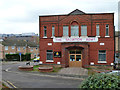
Salvation Army, Redhill
Dated 1890 above, it seems to have four foundation stones as well.
Image: © Robin Webster
Taken: 17 Nov 2010
0.03 miles


6
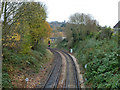
Redhill - Guildford line looking towards Redhill
The third rail only extends as far as Reigate.
Image: © Robin Webster
Taken: 17 Nov 2010
0.04 miles
7
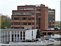
Bridge Gate building, Redhill
An office building.
Image: © Robin Webster
Taken: 17 Nov 2010
0.04 miles
8
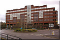
Bridge Gate, Redhill
Offices of Total Gas and Power
Image: © Ian Capper
Taken: 23 Mar 2008
0.05 miles
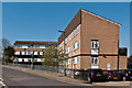
9
Grove House
Part of the Cromwell Road Estate.
Image: © Ian Capper
Taken: 1 Apr 2012
0.05 miles
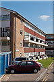
10
Lower Bridge Road
Part of the Cromwell Road Estate, backing onto Lower Bridge Road.
Image: © Ian Capper
Taken: 1 Apr 2012
0.05 miles