IMAGES TAKEN NEAR TO
Reading Arch Road, REDHILL, RH1 1HG
Introduction
This page details the photographs taken nearby to Reading Arch Road, RH1 1HG by members of the Geograph project.
The Geograph project started in 2005 with the aim of publishing, organising and preserving representative images for every square kilometre of Great Britain, Ireland and the Isle of Man.

There are currently over 7.5m images from over14,400 individuals and you can help contribute to the project by visiting https://www.geograph.org.uk
Image Map
Images are licensed for reuse under creativecommons.org/licenses/by-sa/2.0
Notes
- Clicking on the map will re-center to the selected point.
- The higher the marker number, the further away the image location is from the centre of the postcode.
Image Listing (244 Images Found)
Images are licensed for reuse under creativecommons.org/licenses/by-sa/2.0
Image
Details
Distance
2

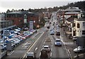
Car Dealer, Brighton Road, Redhill, Surrey
Image: © Stacey Harris
Taken: 21 Mar 2009
0.05 miles

6
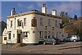
The Garland
Built in 1865 as the Anchor. It was renamed The Garland in the early 1990s, presumably due to its proximity to Garlands Road which runs behind Brighton Road, taking its name from a large house to the southwest called Garlands.
Image: © Ian Capper
Taken: 8 Mar 2009
0.07 miles
8
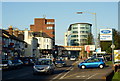
Brighton Road, Redhill, Surrey
Looking towards the town centre.
Image: © Peter Trimming
Taken: 14 Jan 2012
0.07 miles
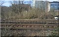
9
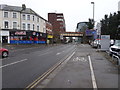
Brighton Road and railway bridge, Redhill
Image: © Nigel Thompson
Taken: 3 Feb 2018
0.07 miles
10
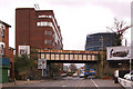
Reading Arch, Redhill
Still known as the Reading Arch, despite no longer being an arch, this bridge carries the Redhill to Guildford railway, originally opened in 1849, over the A23. The office building on the left is Bridge Gate (see Image) and the block in scaffolding on the right is Kingsgate (see Image).
Image: © Ian Capper
Taken: 23 Mar 2008
0.08 miles