IMAGES TAKEN NEAR TO
Station Road, REDHILL, RH1 1HA
Introduction
This page details the photographs taken nearby to Station Road, RH1 1HA by members of the Geograph project.
The Geograph project started in 2005 with the aim of publishing, organising and preserving representative images for every square kilometre of Great Britain, Ireland and the Isle of Man.

There are currently over 7.5m images from over14,400 individuals and you can help contribute to the project by visiting https://www.geograph.org.uk
Image Map
Images are licensed for reuse under creativecommons.org/licenses/by-sa/2.0
Notes
- Clicking on the map will re-center to the selected point.
- The higher the marker number, the further away the image location is from the centre of the postcode.
Image Listing (216 Images Found)
Images are licensed for reuse under creativecommons.org/licenses/by-sa/2.0
Image
Details
Distance
1
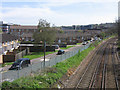
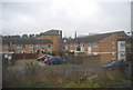
Cromwell Road Estate
A former council estate south of central Redhill. The railway is that running from Redhill to Guildford and Reading. It was opened in 1849 and is electrified as far as Reigate.
Image: © Ian Capper
Taken: 26 Apr 2008
0.08 miles
2
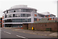
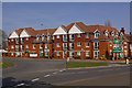
Westgate, Redhill
This building houses offices of Watson Wyatt, Brooklands Group and dmg world media.
Image: © Ian Capper
Taken: 23 Mar 2008
0.08 miles
4
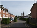
Housing in Fairfax Avenue
Viewed from Holland Close. On the left is Edgehill House, on the right is Marston House. In the foreground is the Fairfax Avenue Play Area.
Image: © Ian Capper
Taken: 26 Apr 2008
0.09 miles
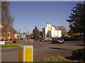
6
Lewis Court
Newly completed retirement housing on Linkfield Corner.
Image: © Ian Capper
Taken: 21 Mar 2009
0.09 miles
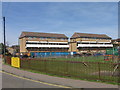
7
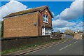
37 Linkfield Street
Single house on Linkfield Street next to the bridge over the Redhill to Reigate railway. A date plaque on the front is inscribed 1910.
Image: © Ian Capper
Taken: 1 Mar 2020
0.10 miles
8
Redhill: St. Matthew's parish church
Image: © Dr Neil Clifton
Taken: 18 Apr 2011
0.10 miles
9
Looking along Furze Close towards St Matthew's spire
Image: © Basher Eyre
Taken: 3 Jan 2017
0.10 miles
10
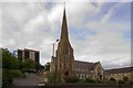
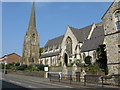
St Matthew's Church and The Dome
St Matthew's Church was built in 1866 to a design of J M K Hähn, and serves the centre of Redhill. It is locally listed.
The block of flats behind, The Dome, took its name from the house on whose site it was built. The original "The Dome" was built by the 19th century amateur astronomer Richard Carrington, after whom the sunspot cycle is named, and included an observatory.
Image: © Ian Capper
Taken: 29 Aug 2011
0.10 miles