IMAGES TAKEN NEAR TO
Hatchlands Road, REDHILL, RH1 1BE
Introduction
This page details the photographs taken nearby to Hatchlands Road, RH1 1BE by members of the Geograph project.
The Geograph project started in 2005 with the aim of publishing, organising and preserving representative images for every square kilometre of Great Britain, Ireland and the Isle of Man.

There are currently over 7.5m images from over14,400 individuals and you can help contribute to the project by visiting https://www.geograph.org.uk
Image Map
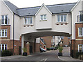
Images are licensed for reuse under creativecommons.org/licenses/by-sa/2.0
Notes
- Clicking on the map will re-center to the selected point.
- The higher the marker number, the further away the image location is from the centre of the postcode.
Image Listing (141 Images Found)
Images are licensed for reuse under creativecommons.org/licenses/by-sa/2.0
Image
Details
Distance
1
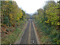
Redhill - Guildford line looking towards Redhill
The third rail only extends west as far as Reigate.
Image: © Robin Webster
Taken: 17 Nov 2010
0.06 miles
3
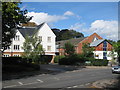
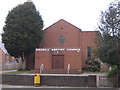
Redhill Baptist Church
On Hatchlands Road. Caberfeigh Close straight ahead.
Image: © Oast House Archive
Taken: 6 Oct 2010
0.08 miles
4
Redhill Baptist Church
In Hatchlands Road, Redhill. The church here was built in 1959, having previously been based in London Road, Redhill, opposite what is now the Harlequin Centre.
Image: © Ian Capper
Taken: 23 Feb 2008
0.09 miles
5
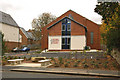
Redhill Baptist Church
Originally built here in 1959, it was completely refurbished in 2009, the new building opening in October of that year. For comparison with previous appearance see Image
Image: © Ian Capper
Taken: 17 Oct 2009
0.09 miles
6
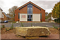
Redhill Baptist Church
Originally built here in 1959, it was completely refurbished in 2009, the new building opening in October of that year. Adjacent to the pavement of Hatchlands Road the pavement, next to a seating area, is this large rock inscribed with the words "hope" and "peace".
Image: © Ian Capper
Taken: 17 Oct 2009
0.09 miles
7
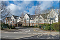
Caberfeigh Close
Development completed in 2004/5, with a mixture of private and "affordable" housing.
Caberfeigh was the name of a large house previously on the site, shown as such on the 1898 6" map, although the 1874 map shows a house on the same site by the name Craven Lodge. On March 1939 it was bought to serve as an Air Raid Precautions headquarters. It later served as the local council housing department offices before being demolished in 2003 and redeveloped as seen here.
Image: © Ian Capper
Taken: 1 Mar 2020
0.09 miles
8
Caberfeigh Close
A new development, with a mixture of private and "affordable" housing.
Caberfeigh was the name of a large house previously on the site, shown as such on the 1898 6" map, although the 1874 map shows a house on the same site by the name Craven Lodge. On March 1939 it was bought to serve as an Air Raid Precautions headquarters. It later served as the local council housing department offices before being demolished in 2003 and redeveloped as seen here.
Image: © Ian Capper
Taken: 23 Feb 2008
0.09 miles
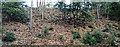
9

Greensand outcrop by the North Downs Line
Image: © N Chadwick
Taken: 30 Jan 2016
0.09 miles