IMAGES TAKEN NEAR TO
Saillard Gardens, RH11 9UE
Introduction
This page details the photographs taken nearby to Saillard Gardens, RH11 9UE by members of the Geograph project.
The Geograph project started in 2005 with the aim of publishing, organising and preserving representative images for every square kilometre of Great Britain, Ireland and the Isle of Man.

There are currently over 7.5m images from over14,400 individuals and you can help contribute to the project by visiting https://www.geograph.org.uk
Image Map
Images are licensed for reuse under creativecommons.org/licenses/by-sa/2.0
Notes
- Clicking on the map will re-center to the selected point.
- The higher the marker number, the further away the image location is from the centre of the postcode.
Image Listing (106 Images Found)
Images are licensed for reuse under creativecommons.org/licenses/by-sa/2.0
Image
Details
Distance
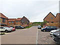
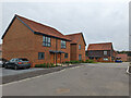
1
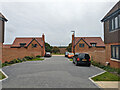
Saillard Gardens, Woodgate, Pease Pottage
A new development.
Image: © Robin Webster
Taken: 16 Oct 2022
0.01 miles
2
Saillard Gardens, Woodgate, Pease Pottage
A new development. A long balancing pond where none was before is on the left.
Image: © Robin Webster
Taken: 16 Oct 2022
0.02 miles
3
Thorn Way, Woodgate, Pease Pottage
A new development.
Image: © Robin Webster
Taken: 16 Oct 2022
0.02 miles
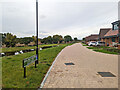
5
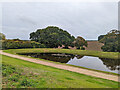
East end of balancing pond, Woodgate, Pease Pottage
A long pond built for this new housing development.
Image: © Robin Webster
Taken: 16 Oct 2022
0.05 miles
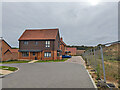
6
Thorn Way, Woodgate, Pease Pottage
A new development.
Image: © Robin Webster
Taken: 16 Oct 2022
0.05 miles
7
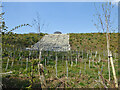
Balancing pond overflow
Part of the new Woodgate development. It is not obvious where any overspill is expected to go, other than generally downhill.
Image: © Robin Webster
Taken: 19 Apr 2021
0.05 miles
8
House on Thorn Way, Woodgate, Pease Pottage
A new development.
Image: © Robin Webster
Taken: 16 Oct 2022
0.05 miles
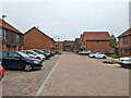
9
Houses on Thorn Way, Woodgate, Pease Pottage
A new development.
Image: © Robin Webster
Taken: 16 Oct 2022
0.05 miles
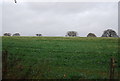
10
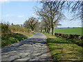
Parish Lane
An old ridgeway route, but now a dead-end for vehicles.
Image: © Robin Webster
Taken: 19 Apr 2021
0.06 miles