IMAGES TAKEN NEAR TO
Kelmscott Rise, CRAWLEY, RH11 9TX
Introduction
This page details the photographs taken nearby to Kelmscott Rise, RH11 9TX by members of the Geograph project.
The Geograph project started in 2005 with the aim of publishing, organising and preserving representative images for every square kilometre of Great Britain, Ireland and the Isle of Man.

There are currently over 7.5m images from over14,400 individuals and you can help contribute to the project by visiting https://www.geograph.org.uk
Image Map
Images are licensed for reuse under creativecommons.org/licenses/by-sa/2.0
Notes
- Clicking on the map will re-center to the selected point.
- The higher the marker number, the further away the image location is from the centre of the postcode.
Image Listing (47 Images Found)
Images are licensed for reuse under creativecommons.org/licenses/by-sa/2.0
Image
Details
Distance
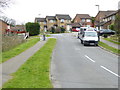
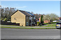
1
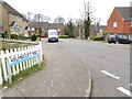
The western end of Hammond Road
At the end of the road is a path between houses.
Image: © Shazz
Taken: 3 Apr 2016
0.03 miles
2
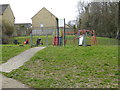
Play area between Hammond Road and William Morris Way
Image: © Shazz
Taken: 3 Apr 2016
0.04 miles

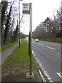
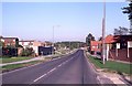
6
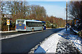
Route 1 bus turns round, Broadfield, Crawley
Metrobus 534 on route 1 has just turned round at the roundabout behind the viewpoint, and will start its service at the bus stop just beyond the traffic islands down the hill.
Image: © Robin Webster
Taken: 19 Dec 2009
0.11 miles
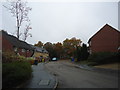
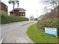
9
Houses on Hollingbourne Crescent, Broadfield, Crawley
Image: © Robin Webster
Taken: 30 Mar 2021
0.16 miles