IMAGES TAKEN NEAR TO
Kensington Road, CRAWLEY, RH11 9NS
Introduction
This page details the photographs taken nearby to Kensington Road, RH11 9NS by members of the Geograph project.
The Geograph project started in 2005 with the aim of publishing, organising and preserving representative images for every square kilometre of Great Britain, Ireland and the Isle of Man.

There are currently over 7.5m images from over14,400 individuals and you can help contribute to the project by visiting https://www.geograph.org.uk
Image Map
Images are licensed for reuse under creativecommons.org/licenses/by-sa/2.0
Notes
- Clicking on the map will re-center to the selected point.
- The higher the marker number, the further away the image location is from the centre of the postcode.
Image Listing (49 Images Found)
Images are licensed for reuse under creativecommons.org/licenses/by-sa/2.0
Image
Details
Distance
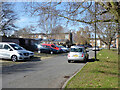
2
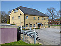
Coachmans Medical Practice, Broadfield, Crawley
Image: © Robin Webster
Taken: 30 Mar 2021
0.06 miles
3
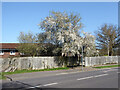
Coachmans Drive South bus stop, Broadfield, Crawley
Served by route 20 on its one-way terminal Broadfield loop.
Image: © Robin Webster
Taken: 30 Mar 2021
0.06 miles
5
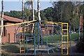
Helicopter climbing frame on Broadfield housing estate
Image: © Peter Shimmon
Taken: 1 Oct 1985
0.07 miles
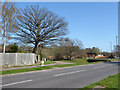
6
Looking northwards on the Guinness Trust Estate
Image: © Peter Shimmon
Taken: 3 Nov 1985
0.08 miles
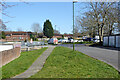
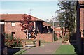
7
Paths by Coachmans Drive, Broadfield, Crawley
Approaches to subways under the roundabout to the right.
Image: © Robin Webster
Taken: 30 Mar 2021
0.08 miles