IMAGES TAKEN NEAR TO
Seaford Road, CRAWLEY, RH11 9HT
Introduction
This page details the photographs taken nearby to Seaford Road, RH11 9HT by members of the Geograph project.
The Geograph project started in 2005 with the aim of publishing, organising and preserving representative images for every square kilometre of Great Britain, Ireland and the Isle of Man.

There are currently over 7.5m images from over14,400 individuals and you can help contribute to the project by visiting https://www.geograph.org.uk
Image Map
Images are licensed for reuse under creativecommons.org/licenses/by-sa/2.0
Notes
- Clicking on the map will re-center to the selected point.
- The higher the marker number, the further away the image location is from the centre of the postcode.
Image Listing (103 Images Found)
Images are licensed for reuse under creativecommons.org/licenses/by-sa/2.0
Image
Details
Distance
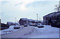
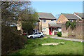
1
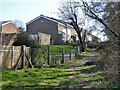
Houses on path off Seaford Road, Broadfield, Crawley
Image: © Robin Webster
Taken: 30 Mar 2021
0.03 miles
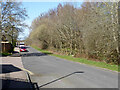
2
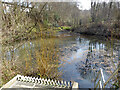
Balancing pond on Creasy's Brook, Broadfield, Crawley
The brook has substantial culverted lengths not far downstream.
Image: © Robin Webster
Taken: 30 Mar 2021
0.05 miles
5
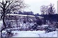
Snow over Broadfield - looking towards Creasy's Brook
Image: © Peter Shimmon
Taken: 9 Jan 1982
0.06 miles
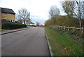
6
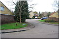
Broadwood Rise
A housing estate on the edge of Crawley.
Image: © N Chadwick
Taken: 26 Nov 2011
0.06 miles
9
Houses at end of Longhurst Road, Broadfield, Crawley
Image: © Robin Webster
Taken: 30 Mar 2021
0.07 miles
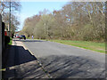
10
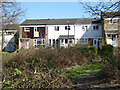
Houses on path off Seaford Road, Broadfield, Crawley
Image: © Robin Webster
Taken: 30 Mar 2021
0.07 miles